Bréhand geodata
Bréhand (Brittany) is a populated place; located in France in Europe/Paris (GMT+2) time zone. With population of 1,321 people, there are 6934 cities with bigger population in this country. Compared to other cities in France, 66.4% of cities are located further ↓South; 96.4% of cities are located further →East and 67.4% of cities have higher elevation than Bréhand. Note1
Administrative division(s):
- Level 1: Brittany
- Level 2: Département des Côtes-d’Armor
- Level 3: Arrondissement de Saint-Brieuc
- Level 4: Bréhand


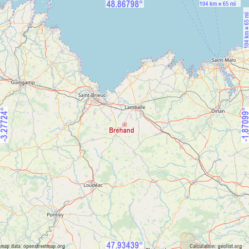
Bréhand GPS coordinates[2]
48° 24' 11.988" North, 2° 34' 26.832" West
| Map corner | latitude | longitude |
|---|---|---|
| Upper-left | 48.86798°, | -3.27724° |
| Center: | 48.40333°, | -2.57412° |
| Lower-right: | 47.93439°, | -1.87099° |
| Map W x H: | 103.8×103.8 km | = 64.5×64.5mi |
| max Lat: | 51.07786° ⇑33.6% North |
| Bréhand: | 48.40333° |
| min Lat: | ⇓66.4% South 41.3874° |
| min Long | Bréhand | max Long |
| -5.08615° | -2.57412° | 9.52242° |
| W 3.6%⇐ | ⇒96.4% E |
Elevation
Elevation of Bréhand is 84 m = 276 ft, and this is 109.7 m = 360 ft below average elevation for this country.
| Max E: |
2333 m = 7654 ft | 67.4% |
| Avg. | 193.7 m = 635 ft | |
| Bréhand | 84 m = 276 ft | |
Min E: |
-1 m = -3 ft | 32.6% |
See also: France elevation on elevation.city.
Geographical zone
Bréhand is located in North temperate zone (between Tropic of Cancer and the Arctic Circle). Distance of this North polar circle is 2019.2 km =1254.7 mi to North.| Distance of | km | miles | from Bréhand |
|---|---|---|---|
| North Pole | 4625.1 | 2873.9 | to North |
| Arctic Circle | 2019.2 | 1254.7 | to North |
| Tropic Cancer | 2776 | 1724.9 | to South |
| Equator | 5381.9 | 3344.2 | to South |


Nearby cities:
15 places around Bréhand: (largest is in red/bold)
• Andel
9.6 km =6 mi,  3°
3°
• Coëtmieux
10 km =6.2 mi,  348°
348°
• Hénon
8.3 km =5.2 mi,  255°
255°
• Lamballe
8.4 km =5.2 mi,  31°
31°
• Landéhen
3.9 km =2.4 mi,  40°
40°
• Le Gouray
10.6 km =6.6 mi,  142°
142°
• Meslin
4.7 km =2.9 mi, 4°
• Moncontour
6.5 km =4 mi,  221°
221°
• Noyal
8.1 km =5 mi,  53°
53°
• Plestan
9.6 km =6 mi,  77°
77°
• Pommeret
7.8 km =4.8 mi,  329°
329°
• Quessoy
6.7 km =4.2 mi,  288°
288°
• Saint-Glen
6.2 km =3.9 mi, 143°
• Trébry
5.6 km =3.5 mi,  162°
162°
• Trédaniel
6 km =3.7 mi,  213°
213°
Sources, notices
• [Note1] Compared only with cities in France existing in our database
• [Src1] Map data: © OpenStreetMap contributors (CC-BY-SA)
• [Src2] Other city data from geonames.org with taken over terms of usage.
• [Src3] Geographical zone / Annual Mean Temperature by Robert A. Rohde @ Wikipedia
