Claye-Souilly geodata
Claye-Souilly (Île-de-France) is a populated place; located in France in Europe/Paris (GMT+2) time zone. With population of 11,069 people, there are 869 cities with bigger population in this country. Compared to other cities in France, 78.4% of cities are located further ↓South; 53.2% of cities are located further ←West and 81.1% of cities have higher elevation than Claye-Souilly. Note1
Administrative division(s):
- Level 1: Île-de-France
- Level 2: Seine-et-Marne
- Level 3: Arrondissement de Meaux
- Level 4: Claye-Souilly


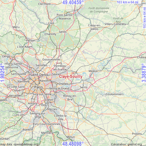
Claye-Souilly GPS coordinates[2]
48° 56' 41.712" North, 2° 41' 8.376" East
| Map corner | latitude | longitude |
|---|---|---|
| Upper-left | 49.40459°, | 1.98254° |
| Center: | 48.94492°, | 2.68566° |
| Lower-right: | 48.48098°, | 3.38879° |
| Map W x H: | 102.7×102.7 km | = 63.8×63.8mi |
| max Lat: | 51.07786° ⇑21.6% North |
| Claye-Souilly: | 48.94492° |
| min Lat: | ⇓78.4% South 41.3874° |
| min Long | Claye-Souilly | max Long |
| -5.08615° | 2.68566° | 9.52242° |
| W 53.2%⇐ | ⇒46.8% E |
Elevation
Elevation of Claye-Souilly is 52 m = 171 ft, and this is 141.7 m = 465 ft below average elevation for this country.
| Max E: |
2333 m = 7654 ft | 81.1% |
| Avg. | 193.7 m = 635 ft | |
| Claye-Souilly | 52 m = 171 ft | |
Min E: |
-1 m = -3 ft | 18.9% |
See also: France elevation on elevation.city.
Geographical zone
Claye-Souilly is located in North temperate zone (between Tropic of Cancer and the Arctic Circle). Distance of this North polar circle is 1959 km =1217.3 mi to North.| Distance of | km | miles | from Claye-Souilly |
|---|---|---|---|
| North Pole | 4564.9 | 2836.5 | to North |
| Arctic Circle | 1959 | 1217.3 | to North |
| Tropic Cancer | 2836.2 | 1762.3 | to South |
| Equator | 5442.2 | 3381.6 | to South |


Nearby cities:
15 places around Claye-Souilly: (largest is in red/bold)
• Annet-sur-Marne
3.2 km =2 mi,  129°
129°
• Charny
6.2 km =3.9 mi,  62°
62°
• Compans
5.7 km =3.5 mi,  344°
344°
• Courtry
6.6 km =4.1 mi,  244°
244°
• Gressy
2.4 km =1.5 mi, 338°
• Jablines
6.4 km =4 mi,  118°
118°
• Le Pin
5.3 km =3.3 mi,  231°
231°
• Messy
2.6 km =1.6 mi,  23°
23°
• Mitry-Mory
6.6 km =4.1 mi,  310°
310°
• Précy-sur-Marne
6.7 km =4.2 mi,  103°
103°
• Saint-Mesmes
4.5 km =2.8 mi,  8°
8°
• Thieux
7 km =4.3 mi,  351°
351°
• Thorigny-sur-Marne
6.9 km =4.3 mi,  159°
159°
• Villeparisis
5.2 km =3.2 mi,  266°
266°
• Villevaudé
3.9 km =2.4 mi,  218°
218°
Sources, notices
• [Note1] Compared only with cities in France existing in our database
• [Src1] Map data: © OpenStreetMap contributors (CC-BY-SA)
• [Src2] Other city data from geonames.org with taken over terms of usage.
• [Src3] Geographical zone / Annual Mean Temperature by Robert A. Rohde @ Wikipedia
