Courtry geodata
Courtry (Île-de-France) is a populated place; located in France in Europe/Paris (GMT+2) time zone. With population of 6,610 people, there are 1491 cities with bigger population in this country. Compared to other cities in France, 78% of cities are located further ↓South; 52.1% of cities are located further ←West and 69.2% of cities have higher elevation than Courtry. Note1
Administrative division(s):
- Level 1: Île-de-France
- Level 2: Seine-et-Marne
- Level 3: Arrondissement de Torcy
- Level 4: Courtry


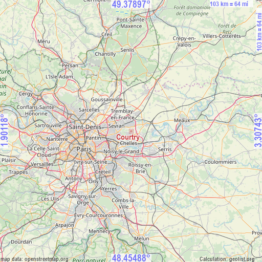
Courtry GPS coordinates[2]
48° 55' 8.616" North, 2° 36' 15.516" East
| Map corner | latitude | longitude |
|---|---|---|
| Upper-left | 49.37897°, | 1.90118° |
| Center: | 48.91906°, | 2.60431° |
| Lower-right: | 48.45488°, | 3.30743° |
| Map W x H: | 102.7×102.7 km | = 63.8×63.8mi |
| max Lat: | 51.07786° ⇑22% North |
| Courtry: | 48.91906° |
| min Lat: | ⇓78% South 41.3874° |
| min Long | Courtry | max Long |
| -5.08615° | 2.60431° | 9.52242° |
| W 52.1%⇐ | ⇒47.9% E |
Elevation
Elevation of Courtry is 80 m = 262 ft, and this is 113.7 m = 373 ft below average elevation for this country.
| Max E: |
2333 m = 7654 ft | 69.2% |
| Avg. | 193.7 m = 635 ft | |
| Courtry | 80 m = 262 ft | |
Min E: |
-1 m = -3 ft | 30.8% |
See also: France elevation on elevation.city.
Geographical zone
Courtry is located in North temperate zone (between Tropic of Cancer and the Arctic Circle). Distance of this North polar circle is 1961.9 km =1219.1 mi to North.| Distance of | km | miles | from Courtry |
|---|---|---|---|
| North Pole | 4567.8 | 2838.3 | to North |
| Arctic Circle | 1961.9 | 1219.1 | to North |
| Tropic Cancer | 2833.4 | 1760.6 | to South |
| Equator | 5439.3 | 3379.8 | to South |


Nearby cities:
15 places around Courtry: (largest is in red/bold)
• Brou-sur-Chantereine
4.5 km =2.8 mi,  151°
151°
• Chelles
4.3 km =2.7 mi,  191°
191°
• Clichy-sous-Bois
3.9 km =2.4 mi,  255°
255°
• Coubron
1.6 km =1 mi, 260°
• Gournay-sur-Marne
6.5 km =4 mi, 192°
• Le Pin
1.8 km =1.1 mi,  103°
103°
• Le Raincy
6.3 km =3.9 mi,  249°
249°
• Livry-Gargan
4.5 km =2.8 mi,  270°
270°
• Montfermeil
3 km =1.9 mi,  218°
218°
• Sevran
6.3 km =3.9 mi,  296°
296°
• Tremblay-en-France
4.3 km =2.7 mi,  322°
322°
• Vaires-sur-Marne
5.4 km =3.4 mi, 151°
• Vaujours
2.7 km =1.7 mi, 297°
• Villeparisis
2.7 km =1.7 mi,  16°
16°
• Villevaudé
3.5 km =2.2 mi,  92°
92°
Sources, notices
• [Note1] Compared only with cities in France existing in our database
• [Src1] Map data: © OpenStreetMap contributors (CC-BY-SA)
• [Src2] Other city data from geonames.org with taken over terms of usage.
• [Src3] Geographical zone / Annual Mean Temperature by Robert A. Rohde @ Wikipedia
