Villevaudé geodata
Villevaudé (Île-de-France) is a populated place; located in France in Europe/Paris (GMT+2) time zone. With population of 1,760 people, there are 5379 cities with bigger population in this country. Compared to other cities in France, 77.9% of cities are located further ↓South; 52.8% of cities are located further ←West and 54.4% of cities have higher elevation than Villevaudé. Note1
Administrative division(s):
- Level 1: Île-de-France
- Level 2: Seine-et-Marne
- Level 3: Arrondissement de Meaux
- Level 4: Villevaudé


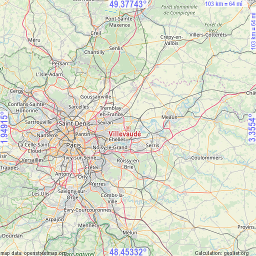
Villevaudé GPS coordinates[2]
48° 55' 3.036" North, 2° 39' 8.208" East
| Map corner | latitude | longitude |
|---|---|---|
| Upper-left | 49.37743°, | 1.94915° |
| Center: | 48.91751°, | 2.65228° |
| Lower-right: | 48.45332°, | 3.3554° |
| Map W x H: | 102.8×102.7 km | = 63.9×63.8mi |
| max Lat: | 51.07786° ⇑22.1% North |
| Villevaudé: | 48.91751° |
| min Lat: | ⇓77.9% South 41.3874° |
| min Long | Villevaudé | max Long |
| -5.08615° | 2.65228° | 9.52242° |
| W 52.8%⇐ | ⇒47.2% E |
Elevation
Elevation of Villevaudé is 118 m = 387 ft, and this is 75.7 m = 248 ft below average elevation for this country.
| Max E: |
2333 m = 7654 ft | 54.4% |
| Avg. | 193.7 m = 635 ft | |
| Villevaudé | 118 m = 387 ft | |
Min E: |
-1 m = -3 ft | 45.6% |
See also: France elevation on elevation.city.
Geographical zone
Villevaudé is located in North temperate zone (between Tropic of Cancer and the Arctic Circle). Distance of this North polar circle is 1962.1 km =1219.2 mi to North.| Distance of | km | miles | from Villevaudé |
|---|---|---|---|
| North Pole | 4567.9 | 2838.4 | to North |
| Arctic Circle | 1962.1 | 1219.2 | to North |
| Tropic Cancer | 2833.2 | 1760.5 | to South |
| Equator | 5439.1 | 3379.7 | to South |


Nearby cities:
15 places around Villevaudé: (largest is in red/bold)
• Annet-sur-Marne
5 km =3.1 mi,  78°
78°
• Brou-sur-Chantereine
4 km =2.5 mi,  200°
200°
• Chelles
5.9 km =3.7 mi,  226°
226°
• Claye-Souilly
3.9 km =2.4 mi,  38°
38°
• Coubron
5 km =3.1 mi,  268°
268°
• Courtry
3.5 km =2.2 mi, 272°
• Gressy
5.5 km =3.4 mi,  16°
16°
• Le Pin
1.8 km =1.1 mi,  261°
261°
• Montfermeil
5.8 km =3.6 mi,  248°
248°
• Pomponne
4.6 km =2.9 mi,  151°
151°
• Saint-Thibault-des-Vignes
5.6 km =3.5 mi,  158°
158°
• Thorigny-sur-Marne
5.9 km =3.7 mi,  125°
125°
• Vaires-sur-Marne
4.7 km =2.9 mi,  191°
191°
• Vaujours
6.1 km =3.8 mi,  283°
283°
• Villeparisis
3.9 km =2.4 mi,  314°
314°
Sources, notices
• [Note1] Compared only with cities in France existing in our database
• [Src1] Map data: © OpenStreetMap contributors (CC-BY-SA)
• [Src2] Other city data from geonames.org with taken over terms of usage.
• [Src3] Geographical zone / Annual Mean Temperature by Robert A. Rohde @ Wikipedia
