Chitenay geodata
Chitenay (Centre) is a populated place; located in France in Europe/Paris (GMT+2) time zone. With population of 1,004 people, there are 8809 cities with bigger population in this country. Compared to other cities in France, 51.1% of cities are located further ↓South; 64.7% of cities are located further →East and 65.6% of cities have higher elevation than Chitenay. Note1
Administrative division(s):
- Level 1: Centre
- Level 2: Département du Loir-et-Cher
- Level 3: Arrondissement de Blois
- Level 4: Chitenay


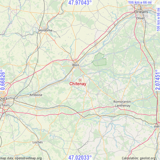
Chitenay GPS coordinates[2]
47° 29' 51.108" North, 1° 22' 17.004" East
| Map corner | latitude | longitude |
|---|---|---|
| Upper-left | 47.97043°, | 0.66826° |
| Center: | 47.49753°, | 1.37139° |
| Lower-right: | 47.02033°, | 2.07451° |
| Map W x H: | 105.6×105.6 km | = 65.6×65.6mi |
| max Lat: | 51.07786° ⇑48.9% North |
| Chitenay: | 47.49753° |
| min Lat: | ⇓51.1% South 41.3874° |
| min Long | Chitenay | max Long |
| -5.08615° | 1.37139° | 9.52242° |
| W 35.3%⇐ | ⇒64.7% E |
Elevation
Elevation of Chitenay is 88 m = 289 ft, and this is 105.7 m = 347 ft below average elevation for this country.
| Max E: |
2333 m = 7654 ft | 65.6% |
| Avg. | 193.7 m = 635 ft | |
| Chitenay | 88 m = 289 ft | |
Min E: |
-1 m = -3 ft | 34.4% |
See also: France elevation on elevation.city.
Geographical zone
Chitenay is located in North temperate zone (between Tropic of Cancer and the Arctic Circle). Distance of this North polar circle is 2119.9 km =1317.2 mi to North.| Distance of | km | miles | from Chitenay |
|---|---|---|---|
| North Pole | 4725.8 | 2936.5 | to North |
| Arctic Circle | 2119.9 | 1317.2 | to North |
| Tropic Cancer | 2675.3 | 1662.4 | to South |
| Equator | 5281.2 | 3281.6 | to South |


Nearby cities:
15 places around Chitenay: (largest is in red/bold)
• Candé-sur-Beuvron
8.4 km =5.2 mi,  268°
268°
• Cellettes
3.4 km =2.1 mi,  12°
12°
• Chailles
6.6 km =4.1 mi,  317°
317°
• Cheverny
6.6 km =4.1 mi,  86°
86°
• Cormeray
2.7 km =1.7 mi,  103°
103°
• Cour-Cheverny
6.5 km =4 mi,  77°
77°
• Feings
6.8 km =4.2 mi,  191°
191°
• Fougères-sur-Bièvre
5.9 km =3.7 mi,  201°
201°
• Fresnes
7.6 km =4.7 mi,  156°
156°
• Les Montils
5.5 km =3.4 mi, 267°
• Monthou-sur-Bièvre
6.2 km =3.9 mi,  247°
247°
• Ouchamps
5.5 km =3.4 mi,  239°
239°
• Saint-Gervais-la-Forêt
7.8 km =4.8 mi,  350°
350°
• Sambin
8.6 km =5.3 mi,  220°
220°
• Vineuil
9.6 km =6 mi,  2°
2°
Sources, notices
• [Note1] Compared only with cities in France existing in our database
• [Src1] Map data: © OpenStreetMap contributors (CC-BY-SA)
• [Src2] Other city data from geonames.org with taken over terms of usage.
• [Src3] Geographical zone / Annual Mean Temperature by Robert A. Rohde @ Wikipedia
