Cour-Cheverny geodata
Cour-Cheverny (Centre) is a populated place; located in France in Europe/Paris (GMT+2) time zone. With population of 2,675 people, there are 3646 cities with bigger population in this country. Compared to other cities in France, 51.4% of cities are located further ↓South; 63.6% of cities are located further →East and 66% of cities have higher elevation than Cour-Cheverny. Note1
Administrative division(s):
- Level 1: Centre
- Level 2: Département du Loir-et-Cher
- Level 3: Arrondissement de Blois
- Level 4: Cour-Cheverny


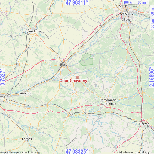
Cour-Cheverny GPS coordinates[2]
47° 30' 37.188" North, 1° 27' 20.988" East
| Map corner | latitude | longitude |
|---|---|---|
| Upper-left | 47.98311°, | 0.7527° |
| Center: | 47.51033°, | 1.45583° |
| Lower-right: | 47.03325°, | 2.15895° |
| Map W x H: | 105.6×105.6 km | = 65.6×65.6mi |
| max Lat: | 51.07786° ⇑48.6% North |
| Cour-Cheverny: | 47.51033° |
| min Lat: | ⇓51.4% South 41.3874° |
| min Long | Cour-Cheverny | max Long |
| -5.08615° | 1.45583° | 9.52242° |
| W 36.4%⇐ | ⇒63.6% E |
Elevation
Elevation of Cour-Cheverny is 87 m = 285 ft, and this is 106.7 m = 350 ft below average elevation for this country.
| Max E: |
2333 m = 7654 ft | 66% |
| Avg. | 193.7 m = 635 ft | |
| Cour-Cheverny | 87 m = 285 ft | |
Min E: |
-1 m = -3 ft | 34% |
See also: France elevation on elevation.city.
Geographical zone
Cour-Cheverny is located in North temperate zone (between Tropic of Cancer and the Arctic Circle). Distance of this North polar circle is 2118.5 km =1316.4 mi to North.| Distance of | km | miles | from Cour-Cheverny |
|---|---|---|---|
| North Pole | 4724.4 | 2935.6 | to North |
| Arctic Circle | 2118.5 | 1316.4 | to North |
| Tropic Cancer | 2676.7 | 1663.2 | to South |
| Equator | 5282.7 | 3282.5 | to South |


Nearby cities:
15 places around Cour-Cheverny: (largest is in red/bold)
• Bracieux
7.7 km =4.8 mi,  56°
56°
• Cellettes
5.9 km =3.7 mi,  288°
288°
• Cheverny
1.1 km =0.7 mi,  165°
165°
• Chitenay
6.5 km =4 mi,  257°
257°
• Contres
10.5 km =6.5 mi,  191°
191°
• Cormeray
4.3 km =2.7 mi,  241°
241°
• Feings
11.1 km =6.9 mi,  223°
223°
• Fontaines-en-Sologne
7.1 km =4.4 mi,  91°
91°
• Fougères-sur-Bièvre
10.9 km =6.8 mi,  231°
231°
• Fresnes
9 km =5.6 mi,  201°
201°
• Huisseau-sur-Cosson
9.2 km =5.7 mi,  358°
358°
• Mont-près-Chambord
5.8 km =3.6 mi,  0°
0°
• Saint-Gervais-la-Forêt
9.9 km =6.2 mi,  309°
309°
• Tour-en-Sologne
5 km =3.1 mi,  48°
48°
• Vineuil
10.1 km =6.3 mi,  323°
323°
Sources, notices
• [Note1] Compared only with cities in France existing in our database
• [Src1] Map data: © OpenStreetMap contributors (CC-BY-SA)
• [Src2] Other city data from geonames.org with taken over terms of usage.
• [Src3] Geographical zone / Annual Mean Temperature by Robert A. Rohde @ Wikipedia
