Cheverny geodata
Cheverny (Centre) is a populated place; located in France in Europe/Paris (GMT+2) time zone. With population of 1,019 people, there are 8696 cities with bigger population in this country. Compared to other cities in France, 51.2% of cities are located further ↓South; 63.5% of cities are located further →East and 62.8% of cities have higher elevation than Cheverny. Note1
Administrative division(s):
- Level 1: Centre
- Level 2: Département du Loir-et-Cher
- Level 3: Arrondissement de Blois
- Level 4: Cheverny


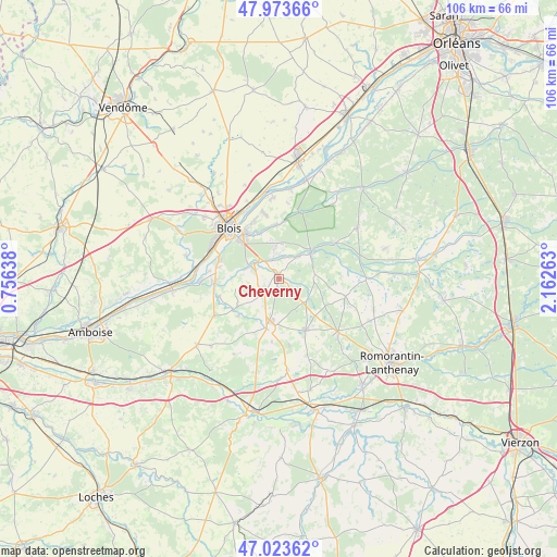
Cheverny GPS coordinates[2]
47° 30' 2.844" North, 1° 27' 34.236" East
| Map corner | latitude | longitude |
|---|---|---|
| Upper-left | 47.97366°, | 0.75638° |
| Center: | 47.50079°, | 1.45951° |
| Lower-right: | 47.02362°, | 2.16263° |
| Map W x H: | 105.6×105.6 km | = 65.6×65.6mi |
| max Lat: | 51.07786° ⇑48.8% North |
| Cheverny: | 47.50079° |
| min Lat: | ⇓51.2% South 41.3874° |
| min Long | Cheverny | max Long |
| -5.08615° | 1.45951° | 9.52242° |
| W 36.5%⇐ | ⇒63.5% E |
Elevation
Elevation of Cheverny is 95 m = 312 ft, and this is 98.7 m = 324 ft below average elevation for this country.
| Max E: |
2333 m = 7654 ft | 62.8% |
| Avg. | 193.7 m = 635 ft | |
| Cheverny | 95 m = 312 ft | |
Min E: |
-1 m = -3 ft | 37.2% |
See also: France elevation on elevation.city.
Geographical zone
Cheverny is located in North temperate zone (between Tropic of Cancer and the Arctic Circle). Distance of this North polar circle is 2119.6 km =1317.1 mi to North.| Distance of | km | miles | from Cheverny |
|---|---|---|---|
| North Pole | 4725.5 | 2936.3 | to North |
| Arctic Circle | 2119.6 | 1317.1 | to North |
| Tropic Cancer | 2675.7 | 1662.6 | to South |
| Equator | 5281.6 | 3281.8 | to South |


Nearby cities:
15 places around Cheverny: (largest is in red/bold)
• Bracieux
8.1 km =5 mi,  48°
48°
• Cellettes
6.6 km =4.1 mi,  296°
296°
• Chitenay
6.6 km =4.1 mi,  266°
266°
• Contres
9.5 km =5.9 mi,  194°
194°
• Cormeray
4.1 km =2.5 mi,  256°
256°
• Cour-Cheverny
1.1 km =0.7 mi,  345°
345°
• Feings
10.6 km =6.6 mi,  228°
228°
• Fontaines-en-Sologne
6.9 km =4.3 mi,  82°
82°
• Fougères-sur-Bièvre
10.5 km =6.5 mi,  236°
236°
• Fresnes
8.1 km =5 mi,  205°
205°
• Huisseau-sur-Cosson
10.3 km =6.4 mi,  357°
357°
• Mont-près-Chambord
6.8 km =4.2 mi, 358°
• Saint-Gervais-la-Forêt
10.8 km =6.7 mi,  313°
313°
• Soings-en-Sologne
10.9 km =6.8 mi,  153°
153°
• Tour-en-Sologne
5.6 km =3.5 mi,  38°
38°
Sources, notices
• [Note1] Compared only with cities in France existing in our database
• [Src1] Map data: © OpenStreetMap contributors (CC-BY-SA)
• [Src2] Other city data from geonames.org with taken over terms of usage.
• [Src3] Geographical zone / Annual Mean Temperature by Robert A. Rohde @ Wikipedia
