Cellettes geodata
Cellettes (Centre) is a populated place; located in France in Europe/Paris (GMT+2) time zone. With population of 2,199 people, there are 4368 cities with bigger population in this country. Compared to other cities in France, 51.7% of cities are located further ↓South; 64.6% of cities are located further →East and 70.5% of cities have higher elevation than Cellettes. Note1
Administrative division(s):
- Level 1: Centre
- Level 2: Département du Loir-et-Cher
- Level 3: Arrondissement de Blois
- Level 4: Cellettes


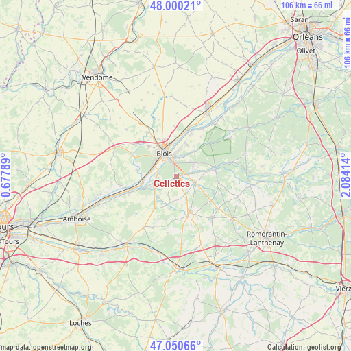
Cellettes GPS coordinates[2]
47° 31' 39.288" North, 1° 22' 51.672" East
| Map corner | latitude | longitude |
|---|---|---|
| Upper-left | 48.00021°, | 0.67789° |
| Center: | 47.52758°, | 1.38102° |
| Lower-right: | 47.05066°, | 2.08414° |
| Map W x H: | 105.6×105.6 km | = 65.6×65.6mi |
| max Lat: | 51.07786° ⇑48.3% North |
| Cellettes: | 47.52758° |
| min Lat: | ⇓51.7% South 41.3874° |
| min Long | Cellettes | max Long |
| -5.08615° | 1.38102° | 9.52242° |
| W 35.4%⇐ | ⇒64.6% E |
Elevation
Elevation of Cellettes is 77 m = 253 ft, and this is 116.7 m = 383 ft below average elevation for this country.
| Max E: |
2333 m = 7654 ft | 70.5% |
| Avg. | 193.7 m = 635 ft | |
| Cellettes | 77 m = 253 ft | |
Min E: |
-1 m = -3 ft | 29.5% |
See also: France elevation on elevation.city.
Geographical zone
Cellettes is located in North temperate zone (between Tropic of Cancer and the Arctic Circle). Distance of this North polar circle is 2116.6 km =1315.2 mi to North.| Distance of | km | miles | from Cellettes |
|---|---|---|---|
| North Pole | 4722.5 | 2934.4 | to North |
| Arctic Circle | 2116.6 | 1315.2 | to North |
| Tropic Cancer | 2678.7 | 1664.5 | to South |
| Equator | 5284.6 | 3283.7 | to South |


Nearby cities:
15 places around Cellettes: (largest is in red/bold)
• Blois
8.4 km =5.2 mi,  332°
332°
• Chailles
5.4 km =3.4 mi,  286°
286°
• Cheverny
6.6 km =4.1 mi,  116°
116°
• Chitenay
3.4 km =2.1 mi,  192°
192°
• Cormeray
4.4 km =2.7 mi,  154°
154°
• Cour-Cheverny
5.9 km =3.7 mi,  108°
108°
• Fougères-sur-Bièvre
9.2 km =5.7 mi,  198°
198°
• Huisseau-sur-Cosson
9.1 km =5.7 mi,  36°
36°
• Les Montils
7.2 km =4.5 mi,  239°
239°
• Mont-près-Chambord
6.9 km =4.3 mi,  55°
55°
• Monthou-sur-Bièvre
8.6 km =5.3 mi,  228°
228°
• Ouchamps
8.2 km =5.1 mi,  221°
221°
• Saint-Gervais-la-Forêt
4.8 km =3 mi,  335°
335°
• Tour-en-Sologne
9.4 km =5.8 mi,  81°
81°
• Vineuil
6.3 km =3.9 mi,  356°
356°
Sources, notices
• [Note1] Compared only with cities in France existing in our database
• [Src1] Map data: © OpenStreetMap contributors (CC-BY-SA)
• [Src2] Other city data from geonames.org with taken over terms of usage.
• [Src3] Geographical zone / Annual Mean Temperature by Robert A. Rohde @ Wikipedia
