Saint-Mathurin-sur-Loire geodata
Saint-Mathurin-sur-Loire (Pays de la Loire) is a populated place; located in France in Europe/Paris (GMT+2) time zone. With population of 2,356 people, there are 4102 cities with bigger population in this country. Compared to other cities in France, 50.1% of cities are located further ↓South; 81.1% of cities are located further →East and 94.4% of cities have higher elevation than Saint-Mathurin-sur-Loire. Note1
Administrative division(s):
- Level 1: Pays de la Loire
- Level 2: Département de Maine-et-Loire
- Level 3: Angers
- Level 4: Loire-Authion
Current local time in Saint-Mathurin-sur-Loire:
03:15 PM, SaturdayDifference from your time zone: hours


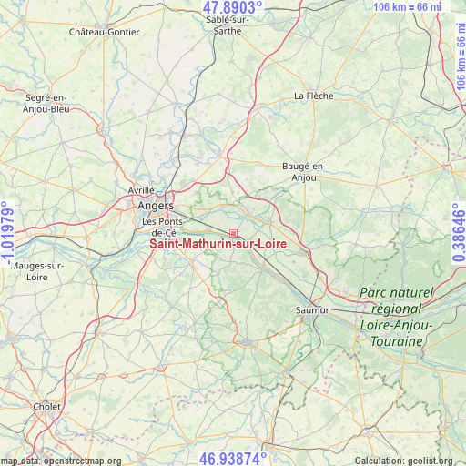
Saint-Mathurin-sur-Loire GPS coordinates[2]
47° 25' 0.012" North, 0° 19' 0.012" West
| Map corner | latitude | longitude |
|---|---|---|
| Upper-left | 47.8903°, | -1.01979° |
| Center: | 47.41667°, | -0.31667° |
| Lower-right: | 46.93874°, | 0.38646° |
| Map W x H: | 105.8×105.8 km | = 65.7×65.7mi |
| max Lat: | 51.07786° ⇑49.9% North |
| Saint-Mathurin-sur-Loire: | 47.41667° |
| min Lat: | ⇓50.1% South 41.3874° |
| min Long | Saint-Mathurin- | max Long |
| -5.08615° | -0.31667° | 9.52242° |
| W 18.9%⇐ | ⇒81.1% E |
Elevation
Elevation of Saint-Mathurin-sur-Loire is 19 m = 62 ft, and this is 174.7 m = 573 ft below average elevation for this country.
| Max E: |
2333 m = 7654 ft | 94.4% |
| Avg. | 193.7 m = 635 ft | |
| Saint-Mathurin-sur-Loire | 19 m = 62 ft | |
Min E: |
-1 m = -3 ft | 5.6% |
See also: France elevation on elevation.city.
Geographical zone
Saint-Mathurin-sur-Loire is located in North temperate zone (between Tropic of Cancer and the Arctic Circle). Distance of this North polar circle is 2128.9 km =1322.8 mi to North.| Distance of | km | miles | from Saint-Mathurin-sur-Loire |
|---|---|---|---|
| North Pole | 4734.8 | 2942.1 | to North |
| Arctic Circle | 2128.9 | 1322.8 | to North |
| Tropic Cancer | 2666.3 | 1656.8 | to South |
| Equator | 5272.2 | 3276 | to South |


Nearby cities:
15 places around Saint-Mathurin-sur-Loire: (largest is in red/bold)
• Andard
7.5 km =4.7 mi,  306°
306°
• Bauné
9.2 km =5.7 mi,  358°
358°
• Beaufort-en-Vallée
7.8 km =4.8 mi,  70°
70°
• Blaison-Gohier
4.9 km =3 mi,  247°
247°
• Charcé-Saint-Ellier-sur-Aubance
9.7 km =6 mi,  227°
227°
• Chemellier
9 km =5.6 mi,  200°
200°
• Corné
6.5 km =4 mi,  337°
337°
• Coutures
6.7 km =4.2 mi,  205°
205°
• La Bohalle
6.1 km =3.8 mi,  274°
274°
• La Daguenière
8.6 km =5.3 mi, 271°
• La Ménitré
4.2 km =2.6 mi,  116°
116°
• Mazé
5.6 km =3.5 mi,  37°
37°
• Saint-Georges-des-Sept-Voies
7.8 km =4.8 mi,  161°
161°
• Saint-Rémy-la-Varenne
2.1 km =1.3 mi,  176°
176°
• Saint-Saturnin-sur-Loire
9.3 km =5.8 mi, 254°
Sources, notices
• [Note1] Compared only with cities in France existing in our database
• [Src1] Map data: © OpenStreetMap contributors (CC-BY-SA)
• [Src2] Other city data from geonames.org with taken over terms of usage.
• [Src3] Geographical zone / Annual Mean Temperature by Robert A. Rohde @ Wikipedia
