Chelles geodata
Chelles (Île-de-France) is a populated place; located in France in Europe/Paris (GMT+2) time zone. With population of 46,947 people, there are 139 cities with bigger population in this country. Compared to other cities in France, 77.2% of cities are located further ↓South; 52% of cities are located further ←West and 84.1% of cities have higher elevation than Chelles. Note1
Administrative division(s):
- Level 1: Île-de-France
- Level 2: Seine-et-Marne
- Level 3: Arrondissement de Torcy
- Level 4: Chelles


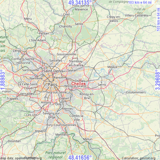
Chelles GPS coordinates[2]
48° 52' 51.924" North, 2° 35' 34.62" East
| Map corner | latitude | longitude |
|---|---|---|
| Upper-left | 49.34135°, | 1.88983° |
| Center: | 48.88109°, | 2.59295° |
| Lower-right: | 48.41656°, | 3.29608° |
| Map W x H: | 102.8×102.8 km | = 63.9×63.9mi |
| max Lat: | 51.07786° ⇑22.8% North |
| Chelles: | 48.88109° |
| min Lat: | ⇓77.2% South 41.3874° |
| min Long | Chelles | max Long |
| -5.08615° | 2.59295° | 9.52242° |
| W 52%⇐ | ⇒48% E |
Elevation
Elevation of Chelles is 44 m = 144 ft, and this is 149.7 m = 491 ft below average elevation for this country.
| Max E: |
2333 m = 7654 ft | 84.1% |
| Avg. | 193.7 m = 635 ft | |
| Chelles | 44 m = 144 ft | |
Min E: |
-1 m = -3 ft | 15.9% |
See also: Chelles elevation on elevation.city.
Geographical zone
Chelles is located in North temperate zone (between Tropic of Cancer and the Arctic Circle). Distance of this North polar circle is 1966.1 km =1221.7 mi to North.| Distance of | km | miles | from Chelles |
|---|---|---|---|
| North Pole | 4572 | 2840.9 | to North |
| Arctic Circle | 1966.1 | 1221.7 | to North |
| Tropic Cancer | 2829.1 | 1757.9 | to South |
| Equator | 5435.1 | 3377.2 | to South |


Nearby cities:
15 places around Chelles: (largest is in red/bold)
• Brou-sur-Chantereine
3 km =1.9 mi,  85°
85°
• Champs-sur-Marne
3.5 km =2.2 mi,  171°
171°
• Clichy-sous-Bois
4.3 km =2.7 mi,  318°
318°
• Coubron
4 km =2.5 mi,  349°
349°
• Courtry
4.3 km =2.7 mi,  11°
11°
• Gagny
4.4 km =2.7 mi,  273°
273°
• Gournay-sur-Marne
2.2 km =1.4 mi,  196°
196°
• Le Pin
4.6 km =2.9 mi,  34°
34°
• Le Raincy
5.5 km =3.4 mi,  291°
291°
• Montfermeil
2.2 km =1.4 mi,  332°
332°
• Neuilly-sur-Marne
4.4 km =2.7 mi,  226°
226°
• Noisiel
4.3 km =2.7 mi,  147°
147°
• Noisy-le-Grand
4.1 km =2.5 mi,  212°
212°
• Torcy
5.4 km =3.4 mi,  128°
128°
• Vaires-sur-Marne
3.5 km =2.2 mi,  98°
98°
Sources, notices
• [Note1] Compared only with cities in France existing in our database
• [Src1] Map data: © OpenStreetMap contributors (CC-BY-SA)
• [Src2] Other city data from geonames.org with taken over terms of usage.
• [Src3] Geographical zone / Annual Mean Temperature by Robert A. Rohde @ Wikipedia
