Montfermeil geodata
Montfermeil (Île-de-France) is a populated place; located in France in Europe/Paris (GMT+2) time zone. With population of 23,829 people, there are 372 cities with bigger population in this country. Compared to other cities in France, 77.5% of cities are located further ↓South; 51.8% of cities are located further ←West and 59.1% of cities have higher elevation than Montfermeil. Note1
Administrative division(s):
- Level 1: Île-de-France
- Level 2: Seine-Saint-Denis
- Level 3: Arrondissement du Raincy
- Level 4: Montfermeil


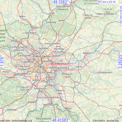
Montfermeil GPS coordinates[2]
48° 53' 53.52" North, 2° 34' 44.868" East
| Map corner | latitude | longitude |
|---|---|---|
| Upper-left | 49.3583°, | 1.876° |
| Center: | 48.8982°, | 2.57913° |
| Lower-right: | 48.43383°, | 3.28225° |
| Map W x H: | 102.8×102.8 km | = 63.9×63.9mi |
| max Lat: | 51.07786° ⇑22.5% North |
| Montfermeil: | 48.8982° |
| min Lat: | ⇓77.5% South 41.3874° |
| min Long | Montfermeil | max Long |
| -5.08615° | 2.57913° | 9.52242° |
| W 51.8%⇐ | ⇒48.2% E |
Elevation
Elevation of Montfermeil is 105 m = 344 ft, and this is 88.7 m = 291 ft below average elevation for this country.
| Max E: |
2333 m = 7654 ft | 59.1% |
| Avg. | 193.7 m = 635 ft | |
| Montfermeil | 105 m = 344 ft | |
Min E: |
-1 m = -3 ft | 40.9% |
See also: France elevation on elevation.city.
Geographical zone
Montfermeil is located in North temperate zone (between Tropic of Cancer and the Arctic Circle). Distance of this North polar circle is 1964.2 km =1220.5 mi to North.| Distance of | km | miles | from Montfermeil |
|---|---|---|---|
| North Pole | 4570.1 | 2839.7 | to North |
| Arctic Circle | 1964.2 | 1220.5 | to North |
| Tropic Cancer | 2831.1 | 1759.2 | to South |
| Equator | 5437 | 3378.4 | to South |


Nearby cities:
15 places around Montfermeil: (largest is in red/bold)
• Brou-sur-Chantereine
4.3 km =2.7 mi,  112°
112°
• Chelles
2.2 km =1.4 mi,  152°
152°
• Clichy-sous-Bois
2.3 km =1.4 mi,  305°
305°
• Coubron
2.1 km =1.3 mi,  8°
8°
• Courtry
3 km =1.9 mi,  38°
38°
• Gagny
3.7 km =2.3 mi,  243°
243°
• Gournay-sur-Marne
4 km =2.5 mi,  174°
174°
• Le Pin
4.1 km =2.5 mi,  62°
62°
• Le Raincy
4.1 km =2.5 mi,  271°
271°
• Les Pavillons-sous-Bois
5.4 km =3.4 mi,  280°
280°
• Livry-Gargan
3.5 km =2.2 mi, 311°
• Neuilly-sur-Marne
5.4 km =3.4 mi,  203°
203°
• Vaires-sur-Marne
5.1 km =3.2 mi,  118°
118°
• Vaujours
3.6 km =2.2 mi,  350°
350°
• Villeparisis
5.5 km =3.4 mi,  27°
27°
Sources, notices
• [Note1] Compared only with cities in France existing in our database
• [Src1] Map data: © OpenStreetMap contributors (CC-BY-SA)
• [Src2] Other city data from geonames.org with taken over terms of usage.
• [Src3] Geographical zone / Annual Mean Temperature by Robert A. Rohde @ Wikipedia
