Clichy-sous-Bois geodata
Clichy-sous-Bois (Île-de-France) is a populated place; located in France in Europe/Paris (GMT+2) time zone. With population of 29,062 people, there are 287 cities with bigger population in this country. Compared to other cities in France, 77.8% of cities are located further ↓South; 51.5% of cities are located further ←West and 55.6% of cities have higher elevation than Clichy-sous-Bois. Note1
Administrative division(s):
- Level 1: Île-de-France
- Level 2: Seine-Saint-Denis
- Level 3: Arrondissement du Raincy
- Level 4: Clichy-sous-Bois


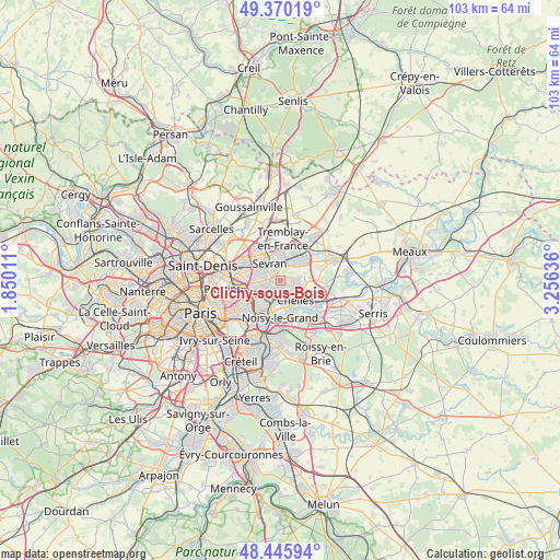
Clichy-sous-Bois GPS coordinates[2]
48° 54' 36.72" North, 2° 33' 11.628" East
| Map corner | latitude | longitude |
|---|---|---|
| Upper-left | 49.37019°, | 1.85011° |
| Center: | 48.9102°, | 2.55323° |
| Lower-right: | 48.44594°, | 3.25636° |
| Map W x H: | 102.8×102.8 km | = 63.9×63.9mi |
| max Lat: | 51.07786° ⇑22.2% North |
| Clichy-sous-Bois: | 48.9102° |
| min Lat: | ⇓77.8% South 41.3874° |
| min Long | Clichy-sous-Boi | max Long |
| -5.08615° | 2.55323° | 9.52242° |
| W 51.5%⇐ | ⇒48.5% E |
Elevation
Elevation of Clichy-sous-Bois is 115 m = 377 ft, and this is 78.7 m = 258 ft below average elevation for this country.
| Max E: |
2333 m = 7654 ft | 55.6% |
| Avg. | 193.7 m = 635 ft | |
| Clichy-sous-Bois | 115 m = 377 ft | |
Min E: |
-1 m = -3 ft | 44.4% |
See also: France elevation on elevation.city.
Geographical zone
Clichy-sous-Bois is located in North temperate zone (between Tropic of Cancer and the Arctic Circle). Distance of this North polar circle is 1962.9 km =1219.7 mi to North.| Distance of | km | miles | from Clichy-sous-Bois |
|---|---|---|---|
| North Pole | 4568.8 | 2838.9 | to North |
| Arctic Circle | 1962.9 | 1219.7 | to North |
| Tropic Cancer | 2832.4 | 1760 | to South |
| Equator | 5438.3 | 3379.2 | to South |


Nearby cities:
15 places around Clichy-sous-Bois: (largest is in red/bold)
• Aulnay-sous-Bois
5.3 km =3.3 mi,  305°
305°
• Bondy
4.8 km =3 mi,  258°
258°
• Chelles
4.3 km =2.7 mi,  138°
138°
• Coubron
2.3 km =1.4 mi,  71°
71°
• Courtry
3.9 km =2.4 mi,  75°
75°
• Gagny
3.3 km =2.1 mi,  205°
205°
• Le Pin
5.5 km =3.4 mi, 84°
• Le Raincy
2.5 km =1.6 mi,  240°
240°
• Les Pavillons-sous-Bois
3.4 km =2.1 mi, 263°
• Livry-Gargan
1.3 km =0.8 mi,  323°
323°
• Montfermeil
2.3 km =1.4 mi,  125°
125°
• Sevran
4.3 km =2.7 mi,  333°
333°
• Tremblay-en-France
4.5 km =2.8 mi,  14°
14°
• Vaujours
2.6 km =1.6 mi,  30°
30°
• Villemomble
4.9 km =3 mi,  232°
232°
Sources, notices
• [Note1] Compared only with cities in France existing in our database
• [Src1] Map data: © OpenStreetMap contributors (CC-BY-SA)
• [Src2] Other city data from geonames.org with taken over terms of usage.
• [Src3] Geographical zone / Annual Mean Temperature by Robert A. Rohde @ Wikipedia
