Chazé-sur-Argos geodata
Chazé-sur-Argos (Pays de la Loire) is a populated place; located in France in Europe/Paris (GMT+2) time zone. With population of 883 people, there are 9798 cities with bigger population in this country. Compared to other cities in France, 52.9% of cities are located further ↓South; 87.2% of cities are located further →East and 88.6% of cities have higher elevation than Chazé-sur-Argos. Note1
Administrative division(s):
- Level 1: Pays de la Loire
- Level 2: Département de Maine-et-Loire
- Level 3: Arrondissement de Segré
- Level 4: Chazé-sur-Argos


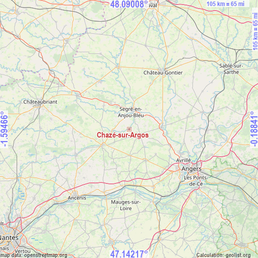
Chazé-sur-Argos GPS coordinates[2]
47° 37' 5.772" North, 0° 53' 29.544" West
| Map corner | latitude | longitude |
|---|---|---|
| Upper-left | 48.09008°, | -1.59466° |
| Center: | 47.61827°, | -0.89154° |
| Lower-right: | 47.14217°, | -0.18841° |
| Map W x H: | 105.4×105.4 km | = 65.5×65.5mi |
| max Lat: | 51.07786° ⇑47.1% North |
| Chazé-sur-Argos: | 47.61827° |
| min Lat: | ⇓52.9% South 41.3874° |
| min Long | Chazé-sur-Argo | max Long |
| -5.08615° | -0.89154° | 9.52242° |
| W 12.8%⇐ | ⇒87.2% E |
Elevation
Elevation of Chazé-sur-Argos is 33 m = 108 ft, and this is 160.7 m = 527 ft below average elevation for this country.
| Max E: |
2333 m = 7654 ft | 88.6% |
| Avg. | 193.7 m = 635 ft | |
| Chazé-sur-Argos | 33 m = 108 ft | |
Min E: |
-1 m = -3 ft | 11.4% |
See also: France elevation on elevation.city.
Geographical zone
Chazé-sur-Argos is located in North temperate zone (between Tropic of Cancer and the Arctic Circle). Distance of this North polar circle is 2106.5 km =1308.9 mi to North.| Distance of | km | miles | from Chazé-sur-Argos |
|---|---|---|---|
| North Pole | 4712.4 | 2928.1 | to North |
| Arctic Circle | 2106.5 | 1308.9 | to North |
| Tropic Cancer | 2688.7 | 1670.7 | to South |
| Equator | 5294.7 | 3290 | to South |


Nearby cities:
15 places around Chazé-sur-Argos: (largest is in red/bold)
• Angrie
8.1 km =5 mi,  229°
229°
• Brain-sur-Longuenée
10.4 km =6.5 mi,  110°
110°
• Candé
12.5 km =7.8 mi,  239°
239°
• Challain-la-Potherie
11.8 km =7.3 mi,  279°
279°
• Combrée
14.1 km =8.8 mi,  312°
312°
• La Chapelle-sur-Oudon
8.1 km =5 mi,  36°
36°
• La Cornuaille
13.8 km =8.6 mi,  210°
210°
• La Pouëze
9.5 km =5.9 mi,  139°
139°
• Le Louroux-Béconnais
10.7 km =6.6 mi,  178°
178°
• Loiré
6.5 km =4 mi,  266°
266°
• Noyant-la-Gravoyère
10.7 km =6.6 mi,  332°
332°
• Nyoiseau
11.1 km =6.9 mi,  350°
350°
• Segré
7.7 km =4.8 mi,  10°
10°
• Vern-d’Anjou
4.7 km =2.9 mi, 113°
• Vritz
14 km =8.7 mi,  253°
253°
Sources, notices
• [Note1] Compared only with cities in France existing in our database
• [Src1] Map data: © OpenStreetMap contributors (CC-BY-SA)
• [Src2] Other city data from geonames.org with taken over terms of usage.
• [Src3] Geographical zone / Annual Mean Temperature by Robert A. Rohde @ Wikipedia
