La Chapelle-sur-Oudon geodata
La Chapelle-sur-Oudon (Pays de la Loire) is a populated place; located in France in Europe/Paris (GMT+2) time zone. With population of 510 people, there are 15036 cities with bigger population in this country. Compared to other cities in France, 53.9% of cities are located further ↓South; 86.7% of cities are located further →East and 81.1% of cities have higher elevation than La Chapelle-sur-Oudon. Note1
Administrative division(s):
- Level 1: Pays de la Loire
- Level 2: Département de Maine-et-Loire
- Level 3: Arrondissement de Segré
- Level 4: Segré-en-Anjou Bleu
Current local time in La Chapelle-sur-Oudon:
03:42 PM, SaturdayDifference from your time zone: hours


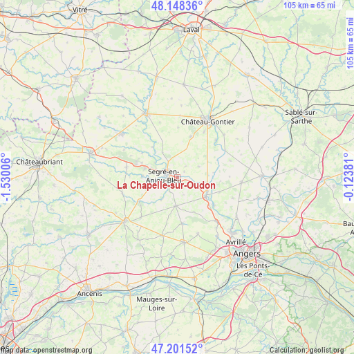
La Chapelle-sur-Oudon GPS coordinates[2]
47° 40' 37.524" North, 0° 49' 36.948" West
| Map corner | latitude | longitude |
|---|---|---|
| Upper-left | 48.14836°, | -1.53006° |
| Center: | 47.67709°, | -0.82693° |
| Lower-right: | 47.20152°, | -0.12381° |
| Map W x H: | 105.3×105.3 km | = 65.4×65.4mi |
| max Lat: | 51.07786° ⇑46.1% North |
| La Chapelle-sur-Oudon: | 47.67709° |
| min Lat: | ⇓53.9% South 41.3874° |
| min Long | La Chapelle-sur | max Long |
| -5.08615° | -0.82693° | 9.52242° |
| W 13.3%⇐ | ⇒86.7% E |
Elevation
Elevation of La Chapelle-sur-Oudon is 52 m = 171 ft, and this is 141.7 m = 465 ft below average elevation for this country.
| Max E: |
2333 m = 7654 ft | 81.1% |
| Avg. | 193.7 m = 635 ft | |
| La Chapelle-sur-Oudon | 52 m = 171 ft | |
Min E: |
-1 m = -3 ft | 18.9% |
See also: France elevation on elevation.city.
Geographical zone
La Chapelle-sur-Oudon is located in North temperate zone (between Tropic of Cancer and the Arctic Circle). Distance of this North polar circle is 2100 km =1304.9 mi to North.| Distance of | km | miles | from La Chapelle-sur-Oudon |
|---|---|---|---|
| North Pole | 4705.9 | 2924.1 | to North |
| Arctic Circle | 2100 | 1304.9 | to North |
| Tropic Cancer | 2695.3 | 1674.8 | to South |
| Equator | 5301.2 | 3294 | to South |


Nearby cities:
15 places around La Chapelle-sur-Oudon: (largest is in red/bold)
• Bouillé-Ménard
12.7 km =7.9 mi,  304°
304°
• Brain-sur-Longuenée
11.4 km =7.1 mi,  154°
154°
• Chazé-sur-Argos
8.1 km =5 mi,  216°
216°
• Chemazé
12.8 km =8 mi,  17°
17°
• Châtelais
11.7 km =7.3 mi,  320°
320°
• Combrée
15.5 km =9.6 mi,  281°
281°
• Grez-Neuville
13.6 km =8.5 mi,  127°
127°
• La Pouëze
13.8 km =8.6 mi,  174°
174°
• Loiré
13.3 km =8.3 mi,  238°
238°
• Montreuil-sur-Maine
10.1 km =6.3 mi,  107°
107°
• Noyant-la-Gravoyère
10.2 km =6.3 mi,  286°
286°
• Nyoiseau
8 km =5 mi, 303°
• Saint-Martin-du-Bois
7.1 km =4.4 mi,  62°
62°
• Segré
3.6 km =2.2 mi, 287°
• Vern-d’Anjou
8.5 km =5.3 mi,  183°
183°
Sources, notices
• [Note1] Compared only with cities in France existing in our database
• [Src1] Map data: © OpenStreetMap contributors (CC-BY-SA)
• [Src2] Other city data from geonames.org with taken over terms of usage.
• [Src3] Geographical zone / Annual Mean Temperature by Robert A. Rohde @ Wikipedia
