Candé geodata
Candé (Pays de la Loire) is a populated place; located in France in Europe/Paris (GMT+2) time zone. With population of 2,755 people, there are 3550 cities with bigger population in this country. Compared to other cities in France, 52.1% of cities are located further ↓South; 88.5% of cities are located further →East and 83.1% of cities have higher elevation than Candé. Note1
Administrative division(s):
- Level 1: Pays de la Loire
- Level 2: Département de Maine-et-Loire
- Level 3: Arrondissement de Segré
- Level 4: Candé


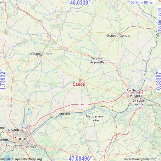
Candé GPS coordinates[2]
47° 33' 41.688" North, 1° 2' 10.284" West
| Map corner | latitude | longitude |
|---|---|---|
| Upper-left | 48.0339°, | -1.73932° |
| Center: | 47.56158°, | -1.03619° |
| Lower-right: | 47.08496°, | -0.33307° |
| Map W x H: | 105.5×105.5 km | = 65.6×65.6mi |
| max Lat: | 51.07786° ⇑47.9% North |
| Candé: | 47.56158° |
| min Lat: | ⇓52.1% South 41.3874° |
| min Long | Candé | max Long |
| -5.08615° | -1.03619° | 9.52242° |
| W 11.5%⇐ | ⇒88.5% E |
Elevation
Elevation of Candé is 47 m = 154 ft, and this is 146.7 m = 481 ft below average elevation for this country.
| Max E: |
2333 m = 7654 ft | 83.1% |
| Avg. | 193.7 m = 635 ft | |
| Candé | 47 m = 154 ft | |
Min E: |
-1 m = -3 ft | 16.9% |
See also: France elevation on elevation.city.
Geographical zone
Candé is located in North temperate zone (between Tropic of Cancer and the Arctic Circle). Distance of this North polar circle is 2112.8 km =1312.8 mi to North.| Distance of | km | miles | from Candé |
|---|---|---|---|
| North Pole | 4718.7 | 2932.1 | to North |
| Arctic Circle | 2112.8 | 1312.8 | to North |
| Tropic Cancer | 2682.4 | 1666.8 | to South |
| Equator | 5288.4 | 3286.1 | to South |


Nearby cities:
15 places around Candé: (largest is in red/bold)
• Angrie
4.8 km =3 mi,  78°
78°
• Belligné
10.5 km =6.5 mi,  176°
176°
• Challain-la-Potherie
8.4 km =5.2 mi,  354°
354°
• Chazé-sur-Argos
12.5 km =7.8 mi,  59°
59°
• Freigné
6.7 km =4.2 mi,  257°
257°
• La Chapelle-Glain
13.7 km =8.5 mi,  299°
299°
• La Chapelle-Saint-Sauveur
13.9 km =8.6 mi,  163°
163°
• La Cornuaille
6.9 km =4.3 mi,  145°
145°
• La Rouxière
13.4 km =8.3 mi,  189°
189°
• Le Louroux-Béconnais
12.1 km =7.5 mi,  111°
111°
• Loiré
7.3 km =4.5 mi,  36°
36°
• Maumusson
10.3 km =6.4 mi,  210°
210°
• Saint-Mars-la-Jaille
11.8 km =7.3 mi,  250°
250°
• Saint-Sulpice-des-Landes
12.9 km =8 mi,  277°
277°
• Vritz
3.4 km =2.1 mi,  310°
310°
Sources, notices
• [Note1] Compared only with cities in France existing in our database
• [Src1] Map data: © OpenStreetMap contributors (CC-BY-SA)
• [Src2] Other city data from geonames.org with taken over terms of usage.
• [Src3] Geographical zone / Annual Mean Temperature by Robert A. Rohde @ Wikipedia
