Segré geodata
Segré (Pays de la Loire) is a seat of a third-order administrative division; located in France in Europe/Paris (GMT+2) time zone. With population of 7,428 people, there are 1314 cities with bigger population in this country. Compared to other cities in France, 54% of cities are located further ↓South; 87.1% of cities are located further →East and 83.1% of cities have higher elevation than Segré. Note1
Administrative division(s):
- Level 1: Pays de la Loire
- Level 2: Département de Maine-et-Loire
- Level 3: Arrondissement de Segré
- Level 4: Segré-en-Anjou Bleu


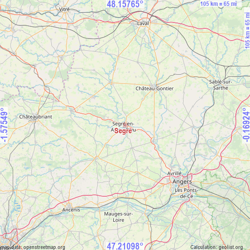
Segré GPS coordinates[2]
47° 41' 11.256" North, 0° 52' 20.532" West
| Map corner | latitude | longitude |
|---|---|---|
| Upper-left | 48.15765°, | -1.57549° |
| Center: | 47.68646°, | -0.87237° |
| Lower-right: | 47.21098°, | -0.16924° |
| Map W x H: | 105.3×105.3 km | = 65.4×65.4mi |
| max Lat: | 51.07786° ⇑46% North |
| Segré: | 47.68646° |
| min Lat: | ⇓54% South 41.3874° |
| min Long | Segré | max Long |
| -5.08615° | -0.87237° | 9.52242° |
| W 12.9%⇐ | ⇒87.1% E |
Elevation
Elevation of Segré is 47 m = 154 ft, and this is 146.7 m = 481 ft below average elevation for this country.
| Max E: |
2333 m = 7654 ft | 83.1% |
| Avg. | 193.7 m = 635 ft | |
| Segré | 47 m = 154 ft | |
Min E: |
-1 m = -3 ft | 16.9% |
See also: France elevation on elevation.city.
Geographical zone
Segré is located in North temperate zone (between Tropic of Cancer and the Arctic Circle). Distance of this North polar circle is 2098.9 km =1304.2 mi to North.| Distance of | km | miles | from Segré |
|---|---|---|---|
| North Pole | 4704.8 | 2923.4 | to North |
| Arctic Circle | 2098.9 | 1304.2 | to North |
| Tropic Cancer | 2696.3 | 1675.4 | to South |
| Equator | 5302.2 | 3294.6 | to South |


Nearby cities:
15 places around Segré: (largest is in red/bold)
• Angrie
15 km =9.3 mi,  210°
210°
• Bouillé-Ménard
9.4 km =5.8 mi,  311°
311°
• Brain-sur-Longuenée
14 km =8.7 mi,  143°
143°
• Challain-la-Potherie
14.2 km =8.8 mi,  246°
246°
• Chazé-sur-Argos
7.7 km =4.8 mi,  190°
190°
• Chemazé
13.3 km =8.3 mi,  33°
33°
• Châtelais
9 km =5.6 mi,  332°
332°
• Combrée
12 km =7.5 mi,  279°
279°
• La Chapelle-sur-Oudon
3.6 km =2.2 mi,  107°
107°
• Loiré
11.2 km =7 mi,  224°
224°
• Montreuil-sur-Maine
13.7 km =8.5 mi, 107°
• Noyant-la-Gravoyère
6.6 km =4.1 mi,  286°
286°
• Nyoiseau
4.7 km =2.9 mi,  315°
315°
• Saint-Martin-du-Bois
10 km =6.2 mi,  77°
77°
• Vern-d’Anjou
9.9 km =6.2 mi,  162°
162°
Sources, notices
• [Note1] Compared only with cities in France existing in our database
• [Src1] Map data: © OpenStreetMap contributors (CC-BY-SA)
• [Src2] Other city data from geonames.org with taken over terms of usage.
• [Src3] Geographical zone / Annual Mean Temperature by Robert A. Rohde @ Wikipedia
