Montbron geodata
Montbron (Nouvelle-Aquitaine) is a populated place; located in France in Europe/Paris (GMT+2) time zone. With population of 2,318 people, there are 4164 cities with bigger population in this country. Compared to other cities in France, 71.5% of cities are located further ↑North; 73.4% of cities are located further →East and 52.8% of cities have lower elevation than Montbron. Note1
Administrative division(s):
- Level 1: Nouvelle-Aquitaine
- Level 2: Charente
- Level 3: Arrondissement d’Angoulême
- Level 4: Montbron


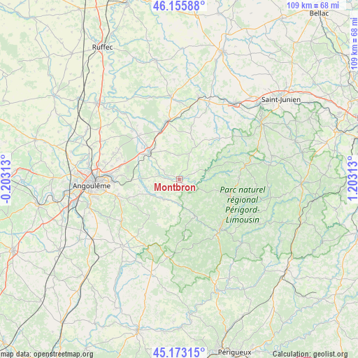
Montbron GPS coordinates[2]
45° 40' 0.012" North, 0° 30' 0" East
| Map corner | latitude | longitude |
|---|---|---|
| Upper-left | 46.15588°, | -0.20313° |
| Center: | 45.66667°, | 0.5° |
| Lower-right: | 45.17315°, | 1.20313° |
| Map W x H: | 109.3×109.3 km | = 67.9×67.9mi |
| max Lat: | 51.07786° ⇑71.5% North |
| Montbron: | 45.66667° |
| min Lat: | ⇓28.5% South 41.3874° |
| min Long | Montbron | max Long |
| -5.08615° | 0.5° | 9.52242° |
| W 26.6%⇐ | ⇒73.4% E |
Elevation
Elevation of Montbron is 142 m = 466 ft, and this is 51.7 m = 170 ft below average elevation for this country.
| Max E: |
2333 m = 7654 ft | 47.2% |
| Avg. | 193.7 m = 635 ft | |
| Montbron | 142 m = 466 ft | |
Min E: |
-1 m = -3 ft | 52.8% |
See also: France elevation on elevation.city.
Geographical zone
Montbron is located in North temperate zone (between Tropic of Cancer and the Arctic Circle). Distance of this North polar circle is 2323.5 km =1443.8 mi to North.| Distance of | km | miles | from Montbron |
|---|---|---|---|
| North Pole | 4929.4 | 3063 | to North |
| Arctic Circle | 2323.5 | 1443.8 | to North |
| Tropic Cancer | 2471.7 | 1535.8 | to South |
| Equator | 5077.7 | 3155.1 | to South |


Nearby cities:
15 places around Montbron: (largest is in red/bold)
• Busserolles
11.1 km =6.9 mi,  84°
84°
• Bussière-Badil
8.3 km =5.2 mi,  101°
101°
• Chazelles
10.5 km =6.5 mi,  258°
258°
• Javerlhac-et-la-Chapelle-Saint-Robert
11.8 km =7.3 mi,  156°
156°
• La Rochefoucauld
12.1 km =7.5 mi,  312°
312°
• Marillac-le-Franc
9 km =5.6 mi,  325°
325°
• Marthon
7.3 km =4.5 mi,  217°
217°
• Montembœuf
13 km =8.1 mi,  18°
18°
• Pranzac
11.7 km =7.3 mi,  270°
270°
• Rivières
14.4 km =8.9 mi, 311°
• Saint-Projet-Saint-Constant
14.3 km =8.9 mi,  298°
298°
• Saint-Sornin
5.7 km =3.5 mi, 300°
• Taponnat-Fleurignac
14.3 km =8.9 mi, 330°
• Vouzan
13.8 km =8.6 mi,  237°
237°
• Écuras
5.6 km =3.5 mi,  70°
70°
Sources, notices
• [Note1] Compared only with cities in France existing in our database
• [Src1] Map data: © OpenStreetMap contributors (CC-BY-SA)
• [Src2] Other city data from geonames.org with taken over terms of usage.
• [Src3] Geographical zone / Annual Mean Temperature by Robert A. Rohde @ Wikipedia
