Chavanoz geodata
Chavanoz (Auvergne-Rhône-Alpes) is a populated place; located in France in Europe/Paris (GMT+2) time zone. With population of 4,265 people, there are 2310 cities with bigger population in this country. Compared to other cities in France, 69.8% of cities are located further ↑North; 79.7% of cities are located further ←West and 65.4% of cities have lower elevation than Chavanoz. Note1
Administrative division(s):
- Level 1: Auvergne-Rhône-Alpes
- Level 2: Département de l'Isère
- Level 3: Arrondissement de La Tour-du-Pin
- Level 4: Chavanoz


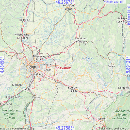
Chavanoz GPS coordinates[2]
45° 46' 6.456" North, 5° 11' 17.088" East
| Map corner | latitude | longitude |
|---|---|---|
| Upper-left | 46.25678°, | 4.48496° |
| Center: | 45.76846°, | 5.18808° |
| Lower-right: | 45.27583°, | 5.89121° |
| Map W x H: | 109.1×109.1 km | = 67.8×67.8mi |
| max Lat: | 51.07786° ⇑69.8% North |
| Chavanoz: | 45.76846° |
| min Lat: | ⇓30.2% South 41.3874° |
| min Long | Chavanoz | max Long |
| -5.08615° | 5.18808° | 9.52242° |
| W 79.7%⇐ | ⇒20.3% E |
Elevation
Elevation of Chavanoz is 196 m = 643 ft, and this is 2.3 m = 8 ft above average elevation for this country.
| Max E: |
2333 m = 7654 ft | 34.6% |
| Chavanoz | 196 m 643 ft | |
| Avg. | 193.7 m = 635 ft | |
Min E: |
-1 m = -3 ft | 65.4% |
See also: France elevation on elevation.city.
Geographical zone
Chavanoz is located in North temperate zone (between Tropic of Cancer and the Arctic Circle). Distance of this North polar circle is 2312.2 km =1436.7 mi to North.| Distance of | km | miles | from Chavanoz |
|---|---|---|---|
| North Pole | 4918.1 | 3056 | to North |
| Arctic Circle | 2312.2 | 1436.7 | to North |
| Tropic Cancer | 2483.1 | 1542.9 | to South |
| Equator | 5089 | 3162.2 | to South |


Nearby cities:
15 places around Chavanoz: (largest is in red/bold)
• Annoisin
8.2 km =5.1 mi,  98°
98°
• Anthon
2.8 km =1.7 mi,  331°
331°
• Charvieu-Chavagneux
3.6 km =2.2 mi,  235°
235°
• Chozeau
7.7 km =4.8 mi,  171°
171°
• Crémieu
6.7 km =4.2 mi,  135°
135°
• Hières-sur-Amby
8.7 km =5.4 mi,  69°
69°
• Janneyrias
6.1 km =3.8 mi,  252°
252°
• Leyrieu
5.4 km =3.4 mi, 100°
• Loyettes
1.7 km =1.1 mi,  58°
58°
• Pont-de-Chéruy
2.1 km =1.3 mi,  215°
215°
• Saint-Jean-de-Niost
7.5 km =4.7 mi,  17°
17°
• Saint-Maurice-de-Gourdans
6 km =3.7 mi,  4°
4°
• Saint-Romain-de-Jalionas
2.6 km =1.6 mi,  119°
119°
• Tignieu
1.9 km =1.2 mi,  177°
177°
• Villemoirieu
6.2 km =3.9 mi,  152°
152°
Sources, notices
• [Note1] Compared only with cities in France existing in our database
• [Src1] Map data: © OpenStreetMap contributors (CC-BY-SA)
• [Src2] Other city data from geonames.org with taken over terms of usage.
• [Src3] Geographical zone / Annual Mean Temperature by Robert A. Rohde @ Wikipedia
