Châtel-Censoir geodata
Châtel-Censoir (Bourgogne-Franche-Comté) is a populated place; located in France in Europe/Paris (GMT+2) time zone. With population of 684 people, there are 12023 cities with bigger population in this country. Compared to other cities in France, 51.7% of cities are located further ↓South; 65.3% of cities are located further ←West and 50.3% of cities have lower elevation than Châtel-Censoir. Note1
Administrative division(s):
- Level 1: Bourgogne-Franche-Comté
- Level 2: Département de l'Yonne
- Level 3: Avallon
- Level 4: Châtel-Censoir


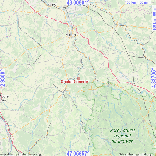
Châtel-Censoir GPS coordinates[2]
47° 32' 0.384" North, 3° 38' 2.148" East
| Map corner | latitude | longitude |
|---|---|---|
| Upper-left | 48.00601°, | 2.9308° |
| Center: | 47.53344°, | 3.63393° |
| Lower-right: | 47.05657°, | 4.33705° |
| Map W x H: | 105.6×105.6 km | = 65.6×65.6mi |
| max Lat: | 51.07786° ⇑48.3% North |
| Châtel-Censoir: | 47.53344° |
| min Lat: | ⇓51.7% South 41.3874° |
| min Long | Châtel-Censoir | max Long |
| -5.08615° | 3.63393° | 9.52242° |
| W 65.3%⇐ | ⇒34.7% E |
Elevation
Elevation of Châtel-Censoir is 133 m = 436 ft, and this is 60.7 m = 199 ft below average elevation for this country.
| Max E: |
2333 m = 7654 ft | 49.7% |
| Avg. | 193.7 m = 635 ft | |
| Châtel-Censoir | 133 m = 436 ft | |
Min E: |
-1 m = -3 ft | 50.3% |
See also: France elevation on elevation.city.
Geographical zone
Châtel-Censoir is located in North temperate zone (between Tropic of Cancer and the Arctic Circle). Distance of this North polar circle is 2116 km =1314.8 mi to North.| Distance of | km | miles | from Châtel-Censoir |
|---|---|---|---|
| North Pole | 4721.8 | 2934 | to North |
| Arctic Circle | 2116 | 1314.8 | to North |
| Tropic Cancer | 2679.3 | 1664.8 | to South |
| Equator | 5285.2 | 3284.1 | to South |


Nearby cities:
15 places around Châtel-Censoir: (largest is in red/bold)
• Clamecy
11.8 km =7.3 mi,  226°
226°
• Coulanges-la-Vineuse
19 km =11.8 mi,  348°
348°
• Coulanges-sur-Yonne
7.1 km =4.4 mi,  263°
263°
• Courson-les-Carrières
13.5 km =8.4 mi,  312°
312°
• Cravant
17.2 km =10.7 mi,  14°
14°
• Dornecy
11.4 km =7.1 mi,  198°
198°
• Escolives-Sainte-Camille
20.6 km =12.8 mi, 354°
• Fontenailles
13 km =8.1 mi,  278°
278°
• Joux-la-Ville
19.8 km =12.3 mi,  59°
59°
• Mailly-la-Ville
8.3 km =5.2 mi,  25°
25°
• Mailly-le-Château
7 km =4.3 mi,  1°
1°
• Tannay
18.7 km =11.6 mi,  189°
189°
• Vermenton
16.4 km =10.2 mi, 27°
• Vincelles
18.8 km =11.7 mi,  359°
359°
• Vézelay
11.3 km =7 mi,  131°
131°
Sources, notices
• [Note1] Compared only with cities in France existing in our database
• [Src1] Map data: © OpenStreetMap contributors (CC-BY-SA)
• [Src2] Other city data from geonames.org with taken over terms of usage.
• [Src3] Geographical zone / Annual Mean Temperature by Robert A. Rohde @ Wikipedia
