Montriond geodata
Montriond (Auvergne-Rhône-Alpes) is a populated place; located in France in Europe/Paris (GMT+2) time zone. With population of 849 people, there are 10089 cities with bigger population in this country. Compared to other cities in France, 63.6% of cities are located further ↑North; 92.9% of cities are located further ←West and 98.6% of cities have lower elevation than Montriond. Note1
Administrative division(s):
- Level 1: Auvergne-Rhône-Alpes
- Level 2: Haute-Savoie
- Level 3: Arrondissement de Thonon-les-Bains
- Level 4: Montriond


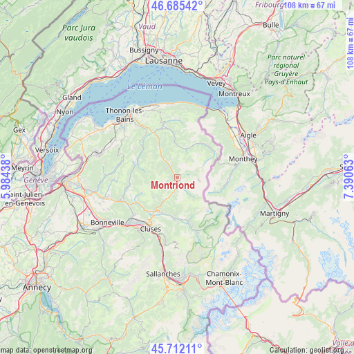
Montriond GPS coordinates[2]
46° 12' 3.312" North, 6° 41' 15" East
| Map corner | latitude | longitude |
|---|---|---|
| Upper-left | 46.68542°, | 5.98438° |
| Center: | 46.20092°, | 6.6875° |
| Lower-right: | 45.71211°, | 7.39063° |
| Map W x H: | 108.2×108.2 km | = 67.2×67.2mi |
| max Lat: | 51.07786° ⇑63.6% North |
| Montriond: | 46.20092° |
| min Lat: | ⇓36.4% South 41.3874° |
| min Long | Montriond | max Long |
| -5.08615° | 6.6875° | 9.52242° |
| W 92.9%⇐ | ⇒7.1% E |
Elevation
Elevation of Montriond is 900 m = 2953 ft, and this is 706.3 m = 2317 ft above average elevation for this country.
| Max E: |
2333 m = 7654 ft | 1.4% |
| Montriond | 900 m 2953 ft | |
| Avg. | 193.7 m = 635 ft | |
Min E: |
-1 m = -3 ft | 98.6% |
See also: France elevation on elevation.city.
Geographical zone
Montriond is located in North temperate zone (between Tropic of Cancer and the Arctic Circle). Distance of this North polar circle is 2264.1 km =1406.8 mi to North.| Distance of | km | miles | from Montriond |
|---|---|---|---|
| North Pole | 4870 | 3026.1 | to North |
| Arctic Circle | 2264.1 | 1406.8 | to North |
| Tropic Cancer | 2531.1 | 1572.8 | to South |
| Equator | 5137.1 | 3192 | to South |


Nearby cities:
15 places around Montriond: (largest is in red/bold)
• Abondance
9 km =5.6 mi,  16°
16°
• Bellevaux
13.5 km =8.4 mi,  298°
298°
• Châtel
13.7 km =8.5 mi,  58°
58°
• Châtillon-sur-Cluses
15.1 km =9.4 mi,  213°
213°
• Les Gets
5.4 km =3.4 mi,  198°
198°
• Lullin
15.7 km =9.8 mi,  306°
306°
• Mieussy
14.6 km =9.1 mi,  239°
239°
• Morillon
13.1 km =8.1 mi,  183°
183°
• Morzine
2.6 km =1.6 mi,  145°
145°
• Saint-Jean-d’Aulps
4.6 km =2.9 mi,  324°
324°
• Saint-Sigismond
15.2 km =9.4 mi, 202°
• Samoëns
13.5 km =8.4 mi,  167°
167°
• Taninges
12.6 km =7.8 mi,  215°
215°
• Vacheresse
13.9 km =8.6 mi,  355°
355°
• Verchaix
11.4 km =7.1 mi, 182°
Sources, notices
• [Note1] Compared only with cities in France existing in our database
• [Src1] Map data: © OpenStreetMap contributors (CC-BY-SA)
• [Src2] Other city data from geonames.org with taken over terms of usage.
• [Src3] Geographical zone / Annual Mean Temperature by Robert A. Rohde @ Wikipedia
