Acigné geodata
Acigné (Brittany) is a populated place; located in France in Europe/Paris (GMT+2) time zone. With population of 5,746 people, there are 1721 cities with bigger population in this country. Compared to other cities in France, 61.7% of cities are located further ↓South; 92.5% of cities are located further →East and 83.8% of cities have higher elevation than Acigné. Note1
Administrative division(s):
- Level 1: Brittany
- Level 2: Département d'Ille-et-Vilaine
- Level 3: Arrondissement de Rennes
- Level 4: Acigné


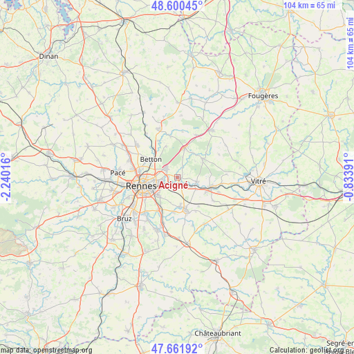
Acigné GPS coordinates[2]
48° 7' 59.988" North, 1° 32' 13.344" West
| Map corner | latitude | longitude |
|---|---|---|
| Upper-left | 48.60045°, | -2.24016° |
| Center: | 48.13333°, | -1.53704° |
| Lower-right: | 47.66192°, | -0.83391° |
| Map W x H: | 104.4×104.4 km | = 64.9×64.9mi |
| max Lat: | 51.07786° ⇑38.3% North |
| Acigné: | 48.13333° |
| min Lat: | ⇓61.7% South 41.3874° |
| min Long | Acigné | max Long |
| -5.08615° | -1.53704° | 9.52242° |
| W 7.5%⇐ | ⇒92.5% E |
Elevation
Elevation of Acigné is 45 m = 148 ft, and this is 148.7 m = 488 ft below average elevation for this country.
| Max E: |
2333 m = 7654 ft | 83.8% |
| Avg. | 193.7 m = 635 ft | |
| Acigné | 45 m = 148 ft | |
Min E: |
-1 m = -3 ft | 16.2% |
See also: France elevation on elevation.city.
Geographical zone
Acigné is located in North temperate zone (between Tropic of Cancer and the Arctic Circle). Distance of this North polar circle is 2049.2 km =1273.3 mi to North.| Distance of | km | miles | from Acigné |
|---|---|---|---|
| North Pole | 4655.1 | 2892.5 | to North |
| Arctic Circle | 2049.2 | 1273.3 | to North |
| Tropic Cancer | 2746 | 1706.3 | to South |
| Equator | 5351.9 | 3325.5 | to South |


Nearby cities:
15 places around Acigné: (largest is in red/bold)
• Betton
9.2 km =5.7 mi,  304°
304°
• Brécé
5 km =3.1 mi,  123°
123°
• Cesson-Sévigné
5.1 km =3.2 mi,  254°
254°
• Chantepie
7.6 km =4.7 mi,  229°
229°
• Châteaubourg
10.5 km =6.5 mi,  103°
103°
• Châteaugiron
10 km =6.2 mi,  165°
165°
• Fouillard
4.2 km =2.6 mi,  311°
311°
• La Bouëxière
9.5 km =5.9 mi,  54°
54°
• Liffré
9.1 km =5.7 mi,  13°
13°
• Nouvoitou
10.3 km =6.4 mi,  184°
184°
• Noyal-sur-Vilaine
2.6 km =1.6 mi,  156°
156°
• Ossé
10.8 km =6.7 mi,  143°
143°
• Rennes
10.5 km =6.5 mi,  256°
256°
• Saint-Sulpice-la-Forêt
9.8 km =6.1 mi,  341°
341°
• Servon-sur-Vilaine
5.9 km =3.7 mi, 103°
Sources, notices
• [Note1] Compared only with cities in France existing in our database
• [Src1] Map data: © OpenStreetMap contributors (CC-BY-SA)
• [Src2] Other city data from geonames.org with taken over terms of usage.
• [Src3] Geographical zone / Annual Mean Temperature by Robert A. Rohde @ Wikipedia
