Brécé geodata
Brécé (Brittany) is a populated place; located in France in Europe/Paris (GMT+2) time zone. With population of 1,572 people, there are 5929 cities with bigger population in this country. Compared to other cities in France, 61.3% of cities are located further ↓South; 92.1% of cities are located further →East and 83.4% of cities have higher elevation than Brécé. Note1
Administrative division(s):
- Level 1: Brittany
- Level 2: Département d'Ille-et-Vilaine
- Level 3: Arrondissement de Rennes
- Level 4: Brécé


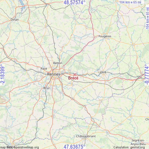
Brécé GPS coordinates[2]
48° 6' 30.204" North, 1° 28' 51.096" West
| Map corner | latitude | longitude |
|---|---|---|
| Upper-left | 48.57574°, | -2.18399° |
| Center: | 48.10839°, | -1.48086° |
| Lower-right: | 47.63675°, | -0.77774° |
| Map W x H: | 104.4×104.4 km | = 64.9×64.9mi |
| max Lat: | 51.07786° ⇑38.7% North |
| Brécé: | 48.10839° |
| min Lat: | ⇓61.3% South 41.3874° |
| min Long | Brécé | max Long |
| -5.08615° | -1.48086° | 9.52242° |
| W 7.9%⇐ | ⇒92.1% E |
Elevation
Elevation of Brécé is 46 m = 151 ft, and this is 147.7 m = 485 ft below average elevation for this country.
| Max E: |
2333 m = 7654 ft | 83.4% |
| Avg. | 193.7 m = 635 ft | |
| Brécé | 46 m = 151 ft | |
Min E: |
-1 m = -3 ft | 16.6% |
See also: France elevation on elevation.city.
Geographical zone
Brécé is located in North temperate zone (between Tropic of Cancer and the Arctic Circle). Distance of this North polar circle is 2052 km =1275.1 mi to North.| Distance of | km | miles | from Brécé |
|---|---|---|---|
| North Pole | 4657.9 | 2894.3 | to North |
| Arctic Circle | 2052 | 1275.1 | to North |
| Tropic Cancer | 2743.2 | 1704.5 | to South |
| Equator | 5349.2 | 3323.8 | to South |


Nearby cities:
15 places around Brécé: (largest is in red/bold)
• Acigné
5 km =3.1 mi,  303°
303°
• Cesson-Sévigné
9.2 km =5.7 mi,  278°
278°
• Chantepie
10.2 km =6.3 mi,  257°
257°
• Châteaubourg
6 km =3.7 mi,  87°
87°
• Châteaugiron
7.1 km =4.4 mi,  194°
194°
• Domagné
7.8 km =4.8 mi,  122°
122°
• Fouillard
9.2 km =5.7 mi,  307°
307°
• La Bouëxière
9 km =5.6 mi,  22°
22°
• Nouvoitou
9 km =5.6 mi,  213°
213°
• Noyal-sur-Vilaine
3.2 km =2 mi, 277°
• Ossé
6.3 km =3.9 mi,  158°
158°
• Saint-Aubin-du-Pavail
7.3 km =4.5 mi,  168°
168°
• Saint-Didier
8.2 km =5.1 mi,  100°
100°
• Saint-Jean-sur-Vilaine
8.9 km =5.5 mi,  84°
84°
• Servon-sur-Vilaine
2.1 km =1.3 mi,  47°
47°
Sources, notices
• [Note1] Compared only with cities in France existing in our database
• [Src1] Map data: © OpenStreetMap contributors (CC-BY-SA)
• [Src2] Other city data from geonames.org with taken over terms of usage.
• [Src3] Geographical zone / Annual Mean Temperature by Robert A. Rohde @ Wikipedia
