Charvonnex geodata
Charvonnex (Auvergne-Rhône-Alpes) is a populated place; located in France in Europe/Paris (GMT+2) time zone. With population of 884 people, there are 9787 cities with bigger population in this country. Compared to other cities in France, 66.5% of cities are located further ↑North; 88.9% of cities are located further ←West and 94.3% of cities have lower elevation than Charvonnex. Note1
Administrative division(s):
- Level 1: Auvergne-Rhône-Alpes
- Level 2: Haute-Savoie
- Level 3: Annecy
- Level 4: Charvonnex


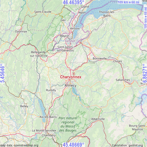
Charvonnex GPS coordinates[2]
45° 58' 38.928" North, 6° 9' 34.488" East
| Map corner | latitude | longitude |
|---|---|---|
| Upper-left | 46.46395°, | 5.45646° |
| Center: | 45.97748°, | 6.15958° |
| Lower-right: | 45.48669°, | 6.86271° |
| Map W x H: | 108.7×108.7 km | = 67.5×67.5mi |
| max Lat: | 51.07786° ⇑66.5% North |
| Charvonnex: | 45.97748° |
| min Lat: | ⇓33.5% South 41.3874° |
| min Long | Charvonnex | max Long |
| -5.08615° | 6.15958° | 9.52242° |
| W 88.9%⇐ | ⇒11.1% E |
Elevation
Elevation of Charvonnex is 555 m = 1821 ft, and this is 361.3 m = 1185 ft above average elevation for this country.
| Max E: |
2333 m = 7654 ft | 5.7% |
| Charvonnex | 555 m 1821 ft | |
| Avg. | 193.7 m = 635 ft | |
Min E: |
-1 m = -3 ft | 94.3% |
See also: France elevation on elevation.city.
Geographical zone
Charvonnex is located in North temperate zone (between Tropic of Cancer and the Arctic Circle). Distance of this North polar circle is 2289 km =1422.3 mi to North.| Distance of | km | miles | from Charvonnex |
|---|---|---|---|
| North Pole | 4894.8 | 3041.5 | to North |
| Arctic Circle | 2289 | 1422.3 | to North |
| Tropic Cancer | 2506.3 | 1557.3 | to South |
| Equator | 5112.2 | 3176.6 | to South |


Nearby cities:
15 places around Charvonnex: (largest is in red/bold)
• Allonzier-la-Caille
4.1 km =2.5 mi,  309°
309°
• Annecy-le-Vieux
6.5 km =4 mi,  190°
190°
• Aviernoz
5.3 km =3.3 mi,  89°
89°
• Choisy
8 km =5 mi,  282°
282°
• Cruseilles
7 km =4.3 mi,  325°
325°
• Cuvat
3.2 km =2 mi,  266°
266°
• Groisy
3.7 km =2.3 mi,  12°
12°
• Les Ollières
1.7 km =1.1 mi, 87°
• Metz
6.2 km =3.9 mi,  218°
218°
• Nâves-Parmelan
5.3 km =3.3 mi,  151°
151°
• Pringy
4.3 km =2.7 mi, 216°
• Saint-Martin-Bellevue
1.7 km =1.1 mi, 185°
• Thorens-Glières
6.9 km =4.3 mi,  73°
73°
• Villaz
4 km =2.5 mi,  137°
137°
• Épagny
7.5 km =4.7 mi,  231°
231°
Sources, notices
• [Note1] Compared only with cities in France existing in our database
• [Src1] Map data: © OpenStreetMap contributors (CC-BY-SA)
• [Src2] Other city data from geonames.org with taken over terms of usage.
• [Src3] Geographical zone / Annual Mean Temperature by Robert A. Rohde @ Wikipedia
