Thorens-Glières geodata
Thorens-Glières (Auvergne-Rhône-Alpes) is a populated place; located in France in Europe/Paris (GMT+2) time zone. With population of 2,829 people, there are 3445 cities with bigger population in this country. Compared to other cities in France, 66.3% of cities are located further ↑North; 89.7% of cities are located further ←West and 96.2% of cities have lower elevation than Thorens-Glières. Note1
Administrative division(s):
- Level 1: Auvergne-Rhône-Alpes
- Level 2: Haute-Savoie
- Level 3: Annecy
- Level 4: Fillière


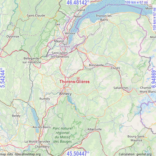
Thorens-Glières GPS coordinates[2]
45° 59' 42.36" North, 6° 14' 44.052" East
| Map corner | latitude | longitude |
|---|---|---|
| Upper-left | 46.48142°, | 5.54244° |
| Center: | 45.9951°, | 6.24557° |
| Lower-right: | 45.50447°, | 6.94869° |
| Map W x H: | 108.6×108.6 km | = 67.5×67.5mi |
| max Lat: | 51.07786° ⇑66.3% North |
| Thorens-Glières: | 45.9951° |
| min Lat: | ⇓33.7% South 41.3874° |
| min Long | Thorens-Glière | max Long |
| -5.08615° | 6.24557° | 9.52242° |
| W 89.7%⇐ | ⇒10.3% E |
Elevation
Elevation of Thorens-Glières is 659 m = 2162 ft, and this is 465.3 m = 1527 ft above average elevation for this country.
| Max E: |
2333 m = 7654 ft | 3.8% |
| Thorens-Glières | 659 m 2162 ft | |
| Avg. | 193.7 m = 635 ft | |
Min E: |
-1 m = -3 ft | 96.2% |
See also: France elevation on elevation.city.
Geographical zone
Thorens-Glières is located in North temperate zone (between Tropic of Cancer and the Arctic Circle). Distance of this North polar circle is 2287 km =1421.1 mi to North.| Distance of | km | miles | from Thorens-Glières |
|---|---|---|---|
| North Pole | 4892.9 | 3040.3 | to North |
| Arctic Circle | 2287 | 1421.1 | to North |
| Tropic Cancer | 2508.3 | 1558.6 | to South |
| Equator | 5114.2 | 3177.8 | to South |


Nearby cities:
15 places around Thorens-Glières: (largest is in red/bold)
• Allonzier-la-Caille
9.8 km =6.1 mi,  273°
273°
• Aviernoz
2.3 km =1.4 mi,  215°
215°
• Charvonnex
6.9 km =4.3 mi,  253°
253°
• Cuvat
10.1 km =6.3 mi,  257°
257°
• Dingy-Saint-Clair
10 km =6.2 mi,  188°
188°
• Etaux
9 km =5.6 mi,  25°
25°
• Groisy
6.1 km =3.8 mi,  285°
285°
• La Roche-sur-Foron
9.6 km =6 mi, 28°
• Les Ollières
5.3 km =3.3 mi, 249°
• Menthonnex-en-Bornes
8.5 km =5.3 mi,  318°
318°
• Nâves-Parmelan
7.8 km =4.8 mi,  211°
211°
• Saint-Martin-Bellevue
7.7 km =4.8 mi,  242°
242°
• Saint-Sixt
9 km =5.6 mi,  45°
45°
• Villaz
6.3 km =3.9 mi, 219°
• Évires
5 km =3.1 mi,  341°
341°
Sources, notices
• [Note1] Compared only with cities in France existing in our database
• [Src1] Map data: © OpenStreetMap contributors (CC-BY-SA)
• [Src2] Other city data from geonames.org with taken over terms of usage.
• [Src3] Geographical zone / Annual Mean Temperature by Robert A. Rohde @ Wikipedia
