Le Grand-Pressigny geodata
Le Grand-Pressigny (Centre) is a populated place; located in France in Europe/Paris (GMT+2) time zone. With population of 1,080 people, there are 8260 cities with bigger population in this country. Compared to other cities in France, 56.1% of cities are located further ↑North; 70.5% of cities are located further →East and 76.2% of cities have higher elevation than Le Grand-Pressigny. Note1
Administrative division(s):
- Level 1: Centre
- Level 2: Département d'Indre-et-Loire
- Level 3: Arrondissement de Loches
- Level 4: Le Grand-Pressigny


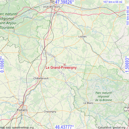
Le Grand-Pressigny GPS coordinates[2]
46° 55' 12.612" North, 0° 48' 13.68" East
| Map corner | latitude | longitude |
|---|---|---|
| Upper-left | 47.39826°, | 0.10067° |
| Center: | 46.92017°, | 0.8038° |
| Lower-right: | 46.43777°, | 1.50693° |
| Map W x H: | 106.8×106.8 km | = 66.4×66.4mi |
| max Lat: | 51.07786° ⇑56.1% North |
| Le Grand-Pressigny: | 46.92017° |
| min Lat: | ⇓43.9% South 41.3874° |
| min Long | Le Grand-Pressi | max Long |
| -5.08615° | 0.8038° | 9.52242° |
| W 29.5%⇐ | ⇒70.5% E |
Elevation
Elevation of Le Grand-Pressigny is 64 m = 210 ft, and this is 129.7 m = 426 ft below average elevation for this country.
| Max E: |
2333 m = 7654 ft | 76.2% |
| Avg. | 193.7 m = 635 ft | |
| Le Grand-Pressigny | 64 m = 210 ft | |
Min E: |
-1 m = -3 ft | 23.8% |
See also: France elevation on elevation.city.
Geographical zone
Le Grand-Pressigny is located in North temperate zone (between Tropic of Cancer and the Arctic Circle). Distance of this North polar circle is 2184.1 km =1357.1 mi to North.| Distance of | km | miles | from Le Grand-Pressigny |
|---|---|---|---|
| North Pole | 4790 | 2976.4 | to North |
| Arctic Circle | 2184.1 | 1357.1 | to North |
| Tropic Cancer | 2611.1 | 1622.5 | to South |
| Equator | 5217 | 3241.7 | to South |


Nearby cities:
15 places around Le Grand-Pressigny: (largest is in red/bold)
• Abilly
5.5 km =3.4 mi,  285°
285°
• Barrou
6.5 km =4 mi,  203°
203°
• Betz-le-Château
11.8 km =7.3 mi,  47°
47°
• Bossay-sur-Claise
15.5 km =9.6 mi,  129°
129°
• Charnizay
13.9 km =8.6 mi,  93°
93°
• Coussay-les-Bois
13.3 km =8.3 mi, 200°
• Cussay
11.6 km =7.2 mi,  354°
354°
• Dangé-Saint-Romain
15.5 km =9.6 mi,  275°
275°
• Descartes
9.4 km =5.8 mi,  303°
303°
• La Roche-Posay
14.9 km =9.3 mi,  177°
177°
• Ligueil
13.6 km =8.5 mi,  4°
4°
• Lésigny
8.4 km =5.2 mi, 200°
• Oyré
14.3 km =8.9 mi,  248°
248°
• Preuilly-sur-Claise
12 km =7.5 mi, 127°
• Yzeures-sur-Creuse
15.8 km =9.8 mi,  160°
160°
Sources, notices
• [Note1] Compared only with cities in France existing in our database
• [Src1] Map data: © OpenStreetMap contributors (CC-BY-SA)
• [Src2] Other city data from geonames.org with taken over terms of usage.
• [Src3] Geographical zone / Annual Mean Temperature by Robert A. Rohde @ Wikipedia
