Barrou geodata
Barrou (Centre) is a populated place; located in France in Europe/Paris (GMT+2) time zone. With population of 512 people, there are 14990 cities with bigger population in this country. Compared to other cities in France, 56.5% of cities are located further ↑North; 70.8% of cities are located further →East and 79.4% of cities have higher elevation than Barrou. Note1
Administrative division(s):
- Level 1: Centre
- Level 2: Département d'Indre-et-Loire
- Level 3: Arrondissement de Loches
- Level 4: Barrou


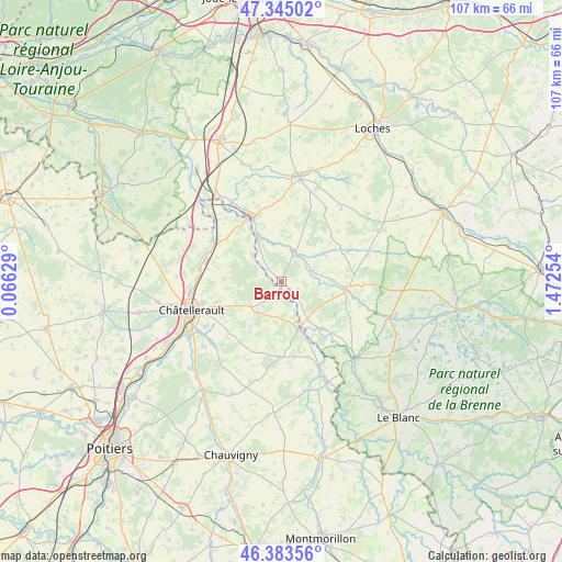
Barrou GPS coordinates[2]
46° 51' 59.184" North, 0° 46' 9.912" East
| Map corner | latitude | longitude |
|---|---|---|
| Upper-left | 47.34502°, | 0.06629° |
| Center: | 46.86644°, | 0.76942° |
| Lower-right: | 46.38356°, | 1.47254° |
| Map W x H: | 106.9×106.9 km | = 66.4×66.4mi |
| max Lat: | 51.07786° ⇑56.5% North |
| Barrou: | 46.86644° |
| min Lat: | ⇓43.5% South 41.3874° |
| min Long | Barrou | max Long |
| -5.08615° | 0.76942° | 9.52242° |
| W 29.2%⇐ | ⇒70.8% E |
Elevation
Elevation of Barrou is 56 m = 184 ft, and this is 137.7 m = 452 ft below average elevation for this country.
| Max E: |
2333 m = 7654 ft | 79.4% |
| Avg. | 193.7 m = 635 ft | |
| Barrou | 56 m = 184 ft | |
Min E: |
-1 m = -3 ft | 20.6% |
See also: France elevation on elevation.city.
Geographical zone
Barrou is located in North temperate zone (between Tropic of Cancer and the Arctic Circle). Distance of this North polar circle is 2190.1 km =1360.9 mi to North.| Distance of | km | miles | from Barrou |
|---|---|---|---|
| North Pole | 4796 | 2980.1 | to North |
| Arctic Circle | 2190.1 | 1360.9 | to North |
| Tropic Cancer | 2605.1 | 1618.7 | to South |
| Equator | 5211.1 | 3238 | to South |


Nearby cities:
15 places around Barrou: (largest is in red/bold)
• Abilly
7.9 km =4.9 mi,  339°
339°
• Bossay-sur-Claise
15.1 km =9.4 mi,  104°
104°
• Coussay-les-Bois
6.8 km =4.2 mi,  197°
197°
• Dangé-Saint-Romain
14.9 km =9.3 mi,  300°
300°
• Descartes
12.3 km =7.6 mi,  334°
334°
• La Roche-Posay
9.5 km =5.9 mi,  159°
159°
• Le Grand-Pressigny
6.5 km =4 mi,  23°
23°
• Lésigny
1.9 km =1.2 mi,  187°
187°
• Oyré
10.8 km =6.7 mi,  273°
273°
• Pleumartin
14.3 km =8.9 mi,  181°
181°
• Preuilly-sur-Claise
12.2 km =7.6 mi, 96°
• Saint-Sauveur
12.9 km =8 mi,  239°
239°
• Senillé
15.3 km =9.5 mi,  230°
230°
• Vaux-sur-Vienne
16.2 km =10.1 mi,  288°
288°
• Yzeures-sur-Creuse
11.8 km =7.3 mi,  138°
138°
Sources, notices
• [Note1] Compared only with cities in France existing in our database
• [Src1] Map data: © OpenStreetMap contributors (CC-BY-SA)
• [Src2] Other city data from geonames.org with taken over terms of usage.
• [Src3] Geographical zone / Annual Mean Temperature by Robert A. Rohde @ Wikipedia
