Châtillon-sur-Indre geodata
Châtillon-sur-Indre (Centre) is a populated place; located in France in Europe/Paris (GMT+2) time zone. With population of 2,873 people, there are 3398 cities with bigger population in this country. Compared to other cities in France, 55.4% of cities are located further ↑North; 67.1% of cities are located further →East and 59.7% of cities have higher elevation than Châtillon-sur-Indre. Note1
Administrative division(s):
- Level 1: Centre
- Level 2: Département de l'Indre
- Level 3: Arrondissement de Châteauroux
- Level 4: Châtillon-sur-Indre


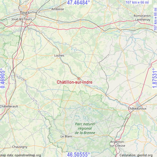
Châtillon-sur-Indre GPS coordinates[2]
46° 59' 14.46" North, 1° 10' 19.848" East
| Map corner | latitude | longitude |
|---|---|---|
| Upper-left | 47.46484°, | 0.46905° |
| Center: | 46.98735°, | 1.17218° |
| Lower-right: | 46.50555°, | 1.87531° |
| Map W x H: | 106.7×106.7 km | = 66.3×66.3mi |
| max Lat: | 51.07786° ⇑55.4% North |
| Châtillon-sur-Indre: | 46.98735° |
| min Lat: | ⇓44.6% South 41.3874° |
| min Long | Châtillon-sur- | max Long |
| -5.08615° | 1.17218° | 9.52242° |
| W 32.9%⇐ | ⇒67.1% E |
Elevation
Elevation of Châtillon-sur-Indre is 103 m = 338 ft, and this is 90.7 m = 298 ft below average elevation for this country.
| Max E: |
2333 m = 7654 ft | 59.7% |
| Avg. | 193.7 m = 635 ft | |
| Châtillon-sur-Indre | 103 m = 338 ft | |
Min E: |
-1 m = -3 ft | 40.3% |
See also: France elevation on elevation.city.
Geographical zone
Châtillon-sur-Indre is located in North temperate zone (between Tropic of Cancer and the Arctic Circle). Distance of this North polar circle is 2176.7 km =1352.5 mi to North.| Distance of | km | miles | from Châtillon-sur-Indre |
|---|---|---|---|
| North Pole | 4782.6 | 2971.8 | to North |
| Arctic Circle | 2176.7 | 1352.5 | to North |
| Tropic Cancer | 2618.6 | 1627.1 | to South |
| Equator | 5224.5 | 3246.4 | to South |


Nearby cities:
15 places around Châtillon-sur-Indre: (largest is in red/bold)
• Azay-le-Ferron
17 km =10.6 mi,  206°
206°
• Bridoré
8.1 km =5 mi,  303°
303°
• Charnizay
16.3 km =10.1 mi,  239°
239°
• Clion
6.9 km =4.3 mi,  138°
138°
• Fléré-la-Rivière
6.1 km =3.8 mi,  306°
306°
• Loché-sur-Indrois
12.2 km =7.6 mi,  17°
17°
• Palluau-sur-Indre
11.8 km =7.3 mi,  114°
114°
• Perrusson
17.2 km =10.7 mi,  316°
316°
• Saint-Flovier
11.2 km =7 mi,  259°
259°
• Saint-Genou
14.1 km =8.8 mi,  117°
117°
• Saint-Hippolyte
9.7 km =6 mi,  325°
325°
• Saint-Jean-Saint-Germain
14.9 km =9.3 mi, 315°
• Verneuil-sur-Indre
12.5 km =7.8 mi, 307°
• Villeloin-Coulangé
17.5 km =10.9 mi,  12°
12°
• Écueillé
17.1 km =10.6 mi,  50°
50°
Sources, notices
• [Note1] Compared only with cities in France existing in our database
• [Src1] Map data: © OpenStreetMap contributors (CC-BY-SA)
• [Src2] Other city data from geonames.org with taken over terms of usage.
• [Src3] Geographical zone / Annual Mean Temperature by Robert A. Rohde @ Wikipedia
