Champigny-sur-Veude geodata
Champigny-sur-Veude (Centre) is a populated place; located in France in Europe/Paris (GMT+2) time zone. With population of 922 people, there are 9460 cities with bigger population in this country. Compared to other cities in France, 54.6% of cities are located further ↑North; 75.1% of cities are located further →East and 82.6% of cities have higher elevation than Champigny-sur-Veude. Note1
Administrative division(s):
- Level 1: Centre
- Level 2: Département d'Indre-et-Loire
- Level 3: Arrondissement de Chinon
- Level 4: Champigny-sur-Veude


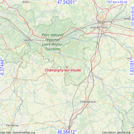
Champigny-sur-Veude GPS coordinates[2]
47° 3' 54.792" North, 0° 19' 43.284" East
| Map corner | latitude | longitude |
|---|---|---|
| Upper-left | 47.54201°, | -0.37444° |
| Center: | 47.06522°, | 0.32869° |
| Lower-right: | 46.58412°, | 1.03181° |
| Map W x H: | 106.5×106.5 km | = 66.2×66.2mi |
| max Lat: | 51.07786° ⇑54.6% North |
| Champigny-sur-Veude: | 47.06522° |
| min Lat: | ⇓45.4% South 41.3874° |
| min Long | Champigny-sur-V | max Long |
| -5.08615° | 0.32869° | 9.52242° |
| W 24.9%⇐ | ⇒75.1% E |
Elevation
Elevation of Champigny-sur-Veude is 48 m = 157 ft, and this is 145.7 m = 478 ft below average elevation for this country.
| Max E: |
2333 m = 7654 ft | 82.6% |
| Avg. | 193.7 m = 635 ft | |
| Champigny-sur-Veude | 48 m = 157 ft | |
Min E: |
-1 m = -3 ft | 17.4% |
See also: France elevation on elevation.city.
Geographical zone
Champigny-sur-Veude is located in North temperate zone (between Tropic of Cancer and the Arctic Circle). Distance of this North polar circle is 2168 km =1347.1 mi to North.| Distance of | km | miles | from Champigny-sur-Veude |
|---|---|---|---|
| North Pole | 4773.9 | 2966.4 | to North |
| Arctic Circle | 2168 | 1347.1 | to North |
| Tropic Cancer | 2627.2 | 1632.5 | to South |
| Equator | 5233.2 | 3251.8 | to South |


Nearby cities:
15 places around Champigny-sur-Veude: (largest is in red/bold)
• Beuxes
11.7 km =7.3 mi,  285°
285°
• Ceaux-en-Loudun
8.1 km =5 mi,  237°
237°
• Chaveignes
3.4 km =2.1 mi,  151°
151°
• Chinon
13 km =8.1 mi,  330°
330°
• Cravant-les-Coteaux
10.4 km =6.5 mi,  7°
7°
• Crouzilles
11.9 km =7.4 mi,  56°
56°
• L'Île-Bouchard
8.8 km =5.5 mi,  49°
49°
• La Roche-Clermault
12.3 km =7.6 mi,  310°
310°
• La Tour-Saint-Gelin
5.9 km =3.7 mi,  107°
107°
• Ligré
6.6 km =4.1 mi,  322°
322°
• Panzoult
10.5 km =6.5 mi,  31°
31°
• Parçay-sur-Vienne
12.1 km =7.5 mi,  68°
68°
• Pouant
7.9 km =4.9 mi,  213°
213°
• Richelieu
5.7 km =3.5 mi,  183°
183°
• Rivière
9.7 km =6 mi,  336°
336°
Sources, notices
• [Note1] Compared only with cities in France existing in our database
• [Src1] Map data: © OpenStreetMap contributors (CC-BY-SA)
• [Src2] Other city data from geonames.org with taken over terms of usage.
• [Src3] Geographical zone / Annual Mean Temperature by Robert A. Rohde @ Wikipedia
