Ligré geodata
Ligré (Centre) is a populated place; located in France in Europe/Paris (GMT+2) time zone. With population of 1,011 people, there are 8765 cities with bigger population in this country. Compared to other cities in France, 54.1% of cities are located further ↑North; 75.5% of cities are located further →East and 80.6% of cities have higher elevation than Ligré. Note1
Administrative division(s):
- Level 1: Centre
- Level 2: Département d'Indre-et-Loire
- Level 3: Arrondissement de Chinon
- Level 4: Ligré


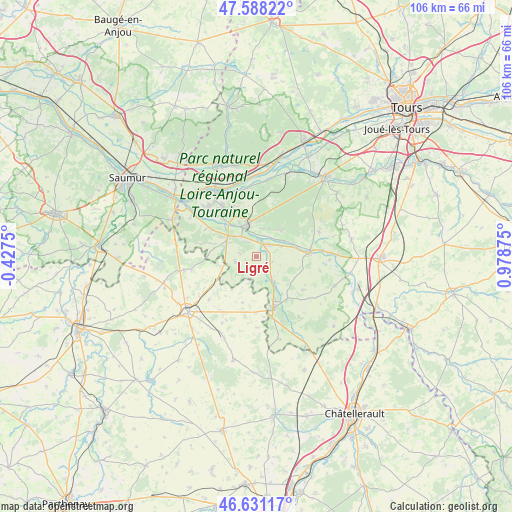
Ligré GPS coordinates[2]
47° 6' 42.66" North, 0° 16' 32.232" East
| Map corner | latitude | longitude |
|---|---|---|
| Upper-left | 47.58822°, | -0.4275° |
| Center: | 47.11185°, | 0.27562° |
| Lower-right: | 46.63117°, | 0.97875° |
| Map W x H: | 106.4×106.4 km | = 66.1×66.1mi |
| max Lat: | 51.07786° ⇑54.1% North |
| Ligré: | 47.11185° |
| min Lat: | ⇓45.9% South 41.3874° |
| min Long | Ligré | max Long |
| -5.08615° | 0.27562° | 9.52242° |
| W 24.5%⇐ | ⇒75.5% E |
Elevation
Elevation of Ligré is 53 m = 174 ft, and this is 140.7 m = 462 ft below average elevation for this country.
| Max E: |
2333 m = 7654 ft | 80.6% |
| Avg. | 193.7 m = 635 ft | |
| Ligré | 53 m = 174 ft | |
Min E: |
-1 m = -3 ft | 19.4% |
See also: France elevation on elevation.city.
Geographical zone
Ligré is located in North temperate zone (between Tropic of Cancer and the Arctic Circle). Distance of this North polar circle is 2162.8 km =1343.9 mi to North.| Distance of | km | miles | from Ligré |
|---|---|---|---|
| North Pole | 4768.7 | 2963.1 | to North |
| Arctic Circle | 2162.8 | 1343.9 | to North |
| Tropic Cancer | 2632.4 | 1635.7 | to South |
| Equator | 5238.3 | 3254.9 | to South |


Nearby cities:
15 places around Ligré: (largest is in red/bold)
• Avoine
12.6 km =7.8 mi,  325°
325°
• Beaumont-en-Véron
11.4 km =7.1 mi,  322°
322°
• Beuxes
7.5 km =4.7 mi,  254°
254°
• Ceaux-en-Loudun
10 km =6.2 mi,  196°
196°
• Champigny-sur-Veude
6.6 km =4.1 mi,  142°
142°
• Chaveignes
9.9 km =6.2 mi,  145°
145°
• Chinon
6.6 km =4.1 mi,  337°
337°
• Cravant-les-Coteaux
7.4 km =4.6 mi,  46°
46°
• L'Île-Bouchard
10.7 km =6.6 mi,  87°
87°
• La Roche-Clermault
6 km =3.7 mi,  298°
298°
• La Tour-Saint-Gelin
11.9 km =7.4 mi,  125°
125°
• Panzoult
10.2 km =6.3 mi,  68°
68°
• Pouant
11.8 km =7.3 mi,  181°
181°
• Richelieu
11.5 km =7.1 mi,  161°
161°
• Rivière
3.7 km =2.3 mi,  3°
3°
Sources, notices
• [Note1] Compared only with cities in France existing in our database
• [Src1] Map data: © OpenStreetMap contributors (CC-BY-SA)
• [Src2] Other city data from geonames.org with taken over terms of usage.
• [Src3] Geographical zone / Annual Mean Temperature by Robert A. Rohde @ Wikipedia
