Champagny-en-Vanoise geodata
Champagny-en-Vanoise (Auvergne-Rhône-Alpes) is a populated place; located in France in Europe/Paris (GMT+2) time zone. With population of 626 people, there are 12883 cities with bigger population in this country. Compared to other cities in France, 74.6% of cities are located further ↑North; 93% of cities are located further ←West and 99.6% of cities have lower elevation than Champagny-en-Vanoise. Note1
Administrative division(s):
- Level 1: Auvergne-Rhône-Alpes
- Level 2: Savoie
- Level 3: Albertville
- Level 4: Champagny-en-Vanoise
Current local time in Champagny-en-Vanoise:
01:40 PM, WednesdayDifference from your time zone: hours


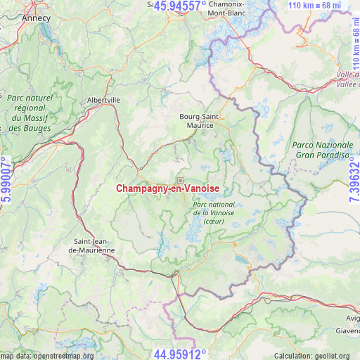
Champagny-en-Vanoise GPS coordinates[2]
45° 27' 16.2" North, 6° 41' 35.52" East
| Map corner | latitude | longitude |
|---|---|---|
| Upper-left | 45.94557°, | 5.99007° |
| Center: | 45.4545°, | 6.6932° |
| Lower-right: | 44.95912°, | 7.39632° |
| Map W x H: | 109.7×109.7 km | = 68.2×68.2mi |
| max Lat: | 51.07786° ⇑74.6% North |
| Champagny-en-Vanoise: | 45.4545° |
| min Lat: | ⇓25.4% South 41.3874° |
| min Long | Champagny-en-Va | max Long |
| -5.08615° | 6.6932° | 9.52242° |
| W 93%⇐ | ⇒7% E |
Elevation
Elevation of Champagny-en-Vanoise is 1212 m = 3976 ft, and this is 1018.3 m = 3341 ft above average elevation for this country.
| Max E: |
2333 m = 7654 ft | 0.40000000000001% |
| Champagny-en-Vanoise | 1212 m 3976 ft | |
| Avg. | 193.7 m = 635 ft | |
Min E: |
-1 m = -3 ft | 99.6% |
See also: France elevation on elevation.city.
Geographical zone
Champagny-en-Vanoise is located in North temperate zone (between Tropic of Cancer and the Arctic Circle). Distance of this North polar circle is 2347.1 km =1458.4 mi to North.| Distance of | km | miles | from Champagny-en-Vanoise |
|---|---|---|---|
| North Pole | 4953 | 3077.7 | to North |
| Arctic Circle | 2347.1 | 1458.4 | to North |
| Tropic Cancer | 2448.1 | 1521.2 | to South |
| Equator | 5054.1 | 3140.5 | to South |


Nearby cities:
15 places around Champagny-en-Vanoise: (largest is in red/bold)
• Aime
11.7 km =7.3 mi,  343°
343°
• Belle-Plagne
6.2 km =3.9 mi,  9°
9°
• Bellentre
12.9 km =8 mi, 7°
• Bozel
3.7 km =2.3 mi,  249°
249°
• Brides-les-Bains
9.7 km =6 mi,  269°
269°
• Courchevel
6.2 km =3.9 mi,  225°
225°
• Landry
13.6 km =8.5 mi,  15°
15°
• Les Allues
11 km =6.8 mi,  257°
257°
• Moûtiers
13 km =8.1 mi,  284°
284°
• Mâcot-la-Plagne
10.8 km =6.7 mi,  348°
348°
• Méribel
10.9 km =6.8 mi, 246°
• Peisey-Nancroix
11.3 km =7 mi,  25°
25°
• Pralognan-la-Vanoise
8.1 km =5 mi,  166°
166°
• Saint-Bon-Tarentaise
5 km =3.1 mi,  242°
242°
• Salins-les-Thermes
12.8 km =8 mi, 278°
Sources, notices
• [Note1] Compared only with cities in France existing in our database
• [Src1] Map data: © OpenStreetMap contributors (CC-BY-SA)
• [Src2] Other city data from geonames.org with taken over terms of usage.
• [Src3] Geographical zone / Annual Mean Temperature by Robert A. Rohde @ Wikipedia
