Bellentre geodata
Bellentre (Auvergne-Rhône-Alpes) is a populated place; located in France in Europe/Paris (GMT+2) time zone. With population of 857 people, there are 10014 cities with bigger population in this country. Compared to other cities in France, 73% of cities are located further ↑North; 93.1% of cities are located further ←West and 97.6% of cities have lower elevation than Bellentre. Note1
Administrative division(s):
- Level 1: Auvergne-Rhône-Alpes
- Level 2: Savoie
- Level 3: Albertville
- Level 4: La Plagne Tarentaise


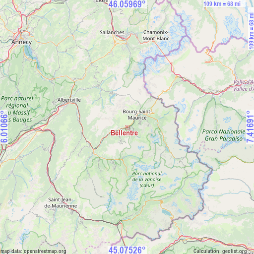
Bellentre GPS coordinates[2]
45° 34' 10.668" North, 6° 42' 49.608" East
| Map corner | latitude | longitude |
|---|---|---|
| Upper-left | 46.05969°, | 6.01066° |
| Center: | 45.56963°, | 6.71378° |
| Lower-right: | 45.07526°, | 7.41691° |
| Map W x H: | 109.5×109.5 km | = 68×68mi |
| max Lat: | 51.07786° ⇑73% North |
| Bellentre: | 45.56963° |
| min Lat: | ⇓27% South 41.3874° |
| min Long | Bellentre | max Long |
| -5.08615° | 6.71378° | 9.52242° |
| W 93.1%⇐ | ⇒6.9% E |
Elevation
Elevation of Bellentre is 780 m = 2559 ft, and this is 586.3 m = 1924 ft above average elevation for this country.
| Max E: |
2333 m = 7654 ft | 2.4% |
| Bellentre | 780 m 2559 ft | |
| Avg. | 193.7 m = 635 ft | |
Min E: |
-1 m = -3 ft | 97.6% |
See also: France elevation on elevation.city.
Geographical zone
Bellentre is located in North temperate zone (between Tropic of Cancer and the Arctic Circle). Distance of this North polar circle is 2334.3 km =1450.5 mi to North.| Distance of | km | miles | from Bellentre |
|---|---|---|---|
| North Pole | 4940.2 | 3069.7 | to North |
| Arctic Circle | 2334.3 | 1450.5 | to North |
| Tropic Cancer | 2460.9 | 1529.1 | to South |
| Equator | 5066.9 | 3148.4 | to South |


Nearby cities:
15 places around Bellentre: (largest is in red/bold)
• Aime
5.2 km =3.2 mi,  252°
252°
• Belle-Plagne
6.7 km =4.2 mi,  184°
184°
• Bourg-Saint-Maurice
6.6 km =4.1 mi,  40°
40°
• Bozel
15 km =9.3 mi,  199°
199°
• Brides-les-Bains
17.2 km =10.7 mi,  221°
221°
• Champagny-en-Vanoise
12.9 km =8 mi,  187°
187°
• Landry
2 km =1.2 mi,  81°
81°
• Montvalezan
11.3 km =7 mi,  65°
65°
• Moûtiers
17.1 km =10.6 mi,  236°
236°
• Mâcot-la-Plagne
4.3 km =2.7 mi, 239°
• Peisey-Nancroix
4.1 km =2.5 mi,  128°
128°
• Saint-Bon-Tarentaise
16.3 km =10.1 mi, 201°
• Sainte-Foy-Tarentaise
13.5 km =8.4 mi, 80°
• Salins-les-Thermes
18 km =11.2 mi,  232°
232°
• Séez
9.1 km =5.7 mi,  48°
48°
Sources, notices
• [Note1] Compared only with cities in France existing in our database
• [Src1] Map data: © OpenStreetMap contributors (CC-BY-SA)
• [Src2] Other city data from geonames.org with taken over terms of usage.
• [Src3] Geographical zone / Annual Mean Temperature by Robert A. Rohde @ Wikipedia
