Belle-Plagne geodata
Belle-Plagne (Auvergne-Rhône-Alpes) is a populated place; located in France in Europe/Paris (GMT+2) time zone. With population of 1,100 people, there are 8130 cities with bigger population in this country. Compared to other cities in France, 74% of cities are located further ↑North; 93.1% of cities are located further ←West and 100% of cities have lower elevation than Belle-Plagne. Note1
Administrative division(s):
- Level 1: Auvergne-Rhône-Alpes
- Level 2: Savoie
- Level 3: Albertville
- Level 4: La Plagne Tarentaise


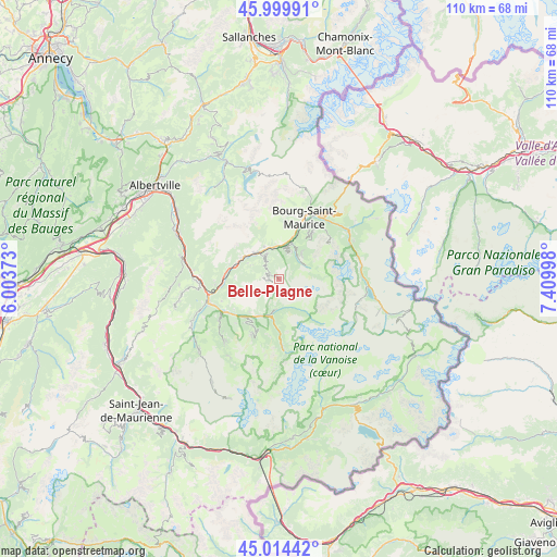
Belle-Plagne GPS coordinates[2]
45° 30' 33.552" North, 6° 42' 24.66" East
| Map corner | latitude | longitude |
|---|---|---|
| Upper-left | 45.99991°, | 6.00373° |
| Center: | 45.50932°, | 6.70685° |
| Lower-right: | 45.01442°, | 7.40998° |
| Map W x H: | 109.6×109.6 km | = 68.1×68.1mi |
| max Lat: | 51.07786° ⇑74% North |
| Belle-Plagne: | 45.50932° |
| min Lat: | ⇓26% South 41.3874° |
| min Long | Belle-Plagne | max Long |
| -5.08615° | 6.70685° | 9.52242° |
| W 93.1%⇐ | ⇒6.9% E |
Elevation
Elevation of Belle-Plagne is 2079 m = 6821 ft, and this is 1885.3 m = 6185 ft above average elevation for this country.
| Max E: |
2333 m = 7654 ft | 0% |
| Belle-Plagne | 2079 m 6821 ft | |
| Avg. | 193.7 m = 635 ft | |
Min E: |
-1 m = -3 ft | 100% |
See also: France elevation on elevation.city.
Geographical zone
Belle-Plagne is located in North temperate zone (between Tropic of Cancer and the Arctic Circle). Distance of this North polar circle is 2341 km =1454.6 mi to North.| Distance of | km | miles | from Belle-Plagne |
|---|---|---|---|
| North Pole | 4946.9 | 3073.9 | to North |
| Arctic Circle | 2341 | 1454.6 | to North |
| Tropic Cancer | 2454.2 | 1525 | to South |
| Equator | 5060.2 | 3144.3 | to South |


Nearby cities:
15 places around Belle-Plagne: (largest is in red/bold)
• Aime
6.8 km =4.2 mi,  319°
319°
• Bellentre
6.7 km =4.2 mi,  4°
4°
• Bourg-Saint-Maurice
12.7 km =7.9 mi,  22°
22°
• Bozel
8.7 km =5.4 mi,  211°
211°
• Brides-les-Bains
12.5 km =7.8 mi,  239°
239°
• Champagny-en-Vanoise
6.2 km =3.9 mi,  189°
189°
• Courchevel
11.8 km =7.3 mi, 207°
• Landry
7.5 km =4.7 mi, 19°
• Les Allues
14.6 km =9.1 mi,  234°
234°
• Moûtiers
13.9 km =8.6 mi,  258°
258°
• Mâcot-la-Plagne
5.5 km =3.4 mi,  325°
325°
• Peisey-Nancroix
5.6 km =3.5 mi,  42°
42°
• Pralognan-la-Vanoise
14 km =8.7 mi,  176°
176°
• Saint-Bon-Tarentaise
10 km =6.2 mi, 212°
• Salins-les-Thermes
14.4 km =8.9 mi,  253°
253°
Sources, notices
• [Note1] Compared only with cities in France existing in our database
• [Src1] Map data: © OpenStreetMap contributors (CC-BY-SA)
• [Src2] Other city data from geonames.org with taken over terms of usage.
• [Src3] Geographical zone / Annual Mean Temperature by Robert A. Rohde @ Wikipedia
