Champagnac-de-Belair geodata
Champagnac-de-Belair (Nouvelle-Aquitaine) is a populated place; located in France in Europe/Paris (GMT+2) time zone. With population of 747 people, there are 11194 cities with bigger population in this country. Compared to other cities in France, 75.3% of cities are located further ↑North; 71.4% of cities are located further →East and 51.7% of cities have lower elevation than Champagnac-de-Belair. Note1
Administrative division(s):
- Level 1: Nouvelle-Aquitaine
- Level 2: Dordogne
- Level 3: Arrondissement de Nontron
- Level 4: Champagnac-de-Belair
Current local time in Champagnac-de-Belair:
03:13 PM, WednesdayDifference from your time zone: hours


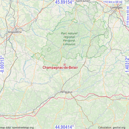
Champagnac-de-Belair GPS coordinates[2]
45° 24' 0" North, 0° 42' 0" East
| Map corner | latitude | longitude |
|---|---|---|
| Upper-left | 45.89154°, | -0.00313° |
| Center: | 45.4°, | 0.7° |
| Lower-right: | 44.90414°, | 1.40312° |
| Map W x H: | 109.8×109.8 km | = 68.2×68.2mi |
| max Lat: | 51.07786° ⇑75.3% North |
| Champagnac-de-Belair: | 45.4° |
| min Lat: | ⇓24.7% South 41.3874° |
| min Long | Champagnac-de-B | max Long |
| -5.08615° | 0.7° | 9.52242° |
| W 28.6%⇐ | ⇒71.4% E |
Elevation
Elevation of Champagnac-de-Belair is 138 m = 453 ft, and this is 55.7 m = 183 ft below average elevation for this country.
| Max E: |
2333 m = 7654 ft | 48.3% |
| Avg. | 193.7 m = 635 ft | |
| Champagnac-de-Belair | 138 m = 453 ft | |
Min E: |
-1 m = -3 ft | 51.7% |
See also: France elevation on elevation.city.
Geographical zone
Champagnac-de-Belair is located in North temperate zone (between Tropic of Cancer and the Arctic Circle). Distance of this North polar circle is 2353.2 km =1462.2 mi to North.| Distance of | km | miles | from Champagnac-de-Belair |
|---|---|---|---|
| North Pole | 4959.1 | 3081.4 | to North |
| Arctic Circle | 2353.2 | 1462.2 | to North |
| Tropic Cancer | 2442.1 | 1517.5 | to South |
| Equator | 5048 | 3136.7 | to South |


Nearby cities:
15 places around Champagnac-de-Belair: (largest is in red/bold)
• Agonac
12.6 km =7.8 mi,  161°
161°
• Bourdeilles
12.4 km =7.7 mi,  225°
225°
• Brantôme
5.6 km =3.5 mi,  219°
219°
• Cornille
17.8 km =11.1 mi, 158°
• Eyzerac
17.3 km =10.7 mi,  94°
94°
• Lisle
17.9 km =11.1 mi, 220°
• Milhac-de-Nontron
9.8 km =6.1 mi,  40°
40°
• Nontron
14.7 km =9.1 mi,  348°
348°
• Négrondes
14.4 km =8.9 mi,  116°
116°
• Saint-Front-la-Rivière
8.3 km =5.2 mi,  15°
15°
• Saint-Martial-de-Valette
13.5 km =8.4 mi,  343°
343°
• Saint-Pardoux-la-Rivière
11.1 km =6.9 mi, 19°
• Sorges
17.1 km =10.6 mi,  127°
127°
• Thiviers
17.2 km =10.7 mi,  84°
84°
• Villars
4.7 km =2.9 mi,  62°
62°
Sources, notices
• [Note1] Compared only with cities in France existing in our database
• [Src1] Map data: © OpenStreetMap contributors (CC-BY-SA)
• [Src2] Other city data from geonames.org with taken over terms of usage.
• [Src3] Geographical zone / Annual Mean Temperature by Robert A. Rohde @ Wikipedia
