Bornel geodata
Bornel (Hauts-de-France) is a populated place; located in France in Europe/Paris (GMT+2) time zone. With population of 3,433 people, there are 2831 cities with bigger population in this country. Compared to other cities in France, 84.2% of cities are located further ↓South; 54.3% of cities are located further →East and 82.2% of cities have higher elevation than Bornel. Note1
Administrative division(s):
- Level 1: Hauts-de-France
- Level 2: Département de l'Oise
- Level 3: Arrondissement de Beauvais
- Level 4: Bornel


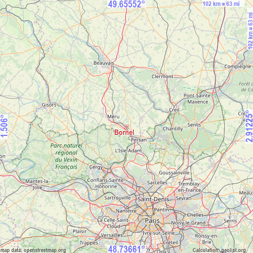
Bornel GPS coordinates[2]
49° 11' 53.52" North, 2° 12' 32.832" East
| Map corner | latitude | longitude |
|---|---|---|
| Upper-left | 49.65552°, | 1.506° |
| Center: | 49.1982°, | 2.20912° |
| Lower-right: | 48.73661°, | 2.91225° |
| Map W x H: | 102.2×102.2 km | = 63.5×63.5mi |
| max Lat: | 51.07786° ⇑15.8% North |
| Bornel: | 49.1982° |
| min Lat: | ⇓84.2% South 41.3874° |
| min Long | Bornel | max Long |
| -5.08615° | 2.20912° | 9.52242° |
| W 45.7%⇐ | ⇒54.3% E |
Elevation
Elevation of Bornel is 49 m = 161 ft, and this is 144.7 m = 475 ft below average elevation for this country.
| Max E: |
2333 m = 7654 ft | 82.2% |
| Avg. | 193.7 m = 635 ft | |
| Bornel | 49 m = 161 ft | |
Min E: |
-1 m = -3 ft | 17.8% |
See also: France elevation on elevation.city.
Geographical zone
Bornel is located in North temperate zone (between Tropic of Cancer and the Arctic Circle). Distance of this North polar circle is 1930.8 km =1199.7 mi to North.| Distance of | km | miles | from Bornel |
|---|---|---|---|
| North Pole | 4536.7 | 2819 | to North |
| Arctic Circle | 1930.8 | 1199.7 | to North |
| Tropic Cancer | 2864.4 | 1779.9 | to South |
| Equator | 5470.3 | 3399.1 | to South |


Nearby cities:
15 places around Bornel: (largest is in red/bold)
• Amblainville
6.3 km =3.9 mi,  276°
276°
• Arronville
7.2 km =4.5 mi,  253°
253°
• Belle-Église
1 km =0.6 mi,  131°
131°
• Chambly
4.6 km =2.9 mi,  139°
139°
• Champagne-sur-Oise
6.9 km =4.3 mi,  159°
159°
• Esches
4 km =2.5 mi,  308°
308°
• Fosseuse
2.3 km =1.4 mi,  315°
315°
• Fresnoy-en-Thelle
4.4 km =2.7 mi,  86°
86°
• Le Mesnil-en-Thelle
6 km =3.7 mi,  111°
111°
• Mortefontaine-en-Thelle
7.5 km =4.7 mi,  348°
348°
• Méru
6.7 km =4.2 mi, 305°
• Neuilly-en-Thelle
6.3 km =3.9 mi,  62°
62°
• Persan
6.8 km =4.2 mi, 137°
• Puiseux-le-Hauberger
2.9 km =1.8 mi,  44°
44°
• Ronquerolles
3.7 km =2.3 mi, 163°
Sources, notices
• [Note1] Compared only with cities in France existing in our database
• [Src1] Map data: © OpenStreetMap contributors (CC-BY-SA)
• [Src2] Other city data from geonames.org with taken over terms of usage.
• [Src3] Geographical zone / Annual Mean Temperature by Robert A. Rohde @ Wikipedia
