Mottier geodata
Mottier (Auvergne-Rhône-Alpes) is a populated place; located in France in Europe/Paris (GMT+2) time zone. With population of 615 people, there are 13071 cities with bigger population in this country. Compared to other cities in France, 75% of cities are located further ↑North; 80.7% of cities are located further ←West and 92.2% of cities have lower elevation than Mottier. Note1
Administrative division(s):
- Level 1: Auvergne-Rhône-Alpes
- Level 2: Département de l'Isère
- Level 3: Arrondissement de Vienne
- Level 4: Mottier


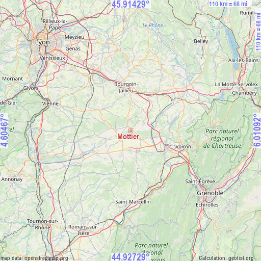
Mottier GPS coordinates[2]
45° 25' 22.62" North, 5° 18' 28.08" East
| Map corner | latitude | longitude |
|---|---|---|
| Upper-left | 45.91429°, | 4.60467° |
| Center: | 45.42295°, | 5.3078° |
| Lower-right: | 44.92729°, | 6.01092° |
| Map W x H: | 109.7×109.7 km | = 68.2×68.2mi |
| max Lat: | 51.07786° ⇑75% North |
| Mottier: | 45.42295° |
| min Lat: | ⇓25% South 41.3874° |
| min Long | Mottier | max Long |
| -5.08615° | 5.3078° | 9.52242° |
| W 80.7%⇐ | ⇒19.3% E |
Elevation
Elevation of Mottier is 480 m = 1575 ft, and this is 286.3 m = 939 ft above average elevation for this country.
| Max E: |
2333 m = 7654 ft | 7.8% |
| Mottier | 480 m 1575 ft | |
| Avg. | 193.7 m = 635 ft | |
Min E: |
-1 m = -3 ft | 92.2% |
See also: France elevation on elevation.city.
Geographical zone
Mottier is located in North temperate zone (between Tropic of Cancer and the Arctic Circle). Distance of this North polar circle is 2350.6 km =1460.6 mi to North.| Distance of | km | miles | from Mottier |
|---|---|---|---|
| North Pole | 4956.5 | 3079.8 | to North |
| Arctic Circle | 2350.6 | 1460.6 | to North |
| Tropic Cancer | 2444.6 | 1519 | to South |
| Equator | 5050.6 | 3138.3 | to South |


Nearby cities:
15 places around Mottier: (largest is in red/bold)
• Badinières
9.5 km =5.9 mi,  357°
357°
• Biol
9.7 km =6 mi,  38°
38°
• Bizonnes
6.5 km =4 mi,  59°
59°
• Brézins
7.9 km =4.9 mi,  181°
181°
• Bévenais
7.3 km =4.5 mi,  113°
113°
• Champier
3.8 km =2.4 mi,  341°
341°
• Châbons
9.4 km =5.8 mi,  76°
76°
• Commelle
6.4 km =4 mi,  275°
275°
• Eclose
8.4 km =5.2 mi, 355°
• Gillonnay
3.5 km =2.2 mi,  197°
197°
• La Côte-Saint-André
4.9 km =3 mi,  230°
230°
• La Frette
5.5 km =3.4 mi,  133°
133°
• Le Grand-Lemps
9.2 km =5.7 mi, 108°
• Saint-Hilaire-de-la-Côte
3.5 km =2.2 mi,  169°
169°
• Sardieu
9.6 km =6 mi, 231°
Sources, notices
• [Note1] Compared only with cities in France existing in our database
• [Src1] Map data: © OpenStreetMap contributors (CC-BY-SA)
• [Src2] Other city data from geonames.org with taken over terms of usage.
• [Src3] Geographical zone / Annual Mean Temperature by Robert A. Rohde @ Wikipedia
