Cers geodata
Cers (Occitanie) is a populated place; located in France in Europe/Paris (GMT+2) time zone. With population of 2,037 people, there are 4712 cities with bigger population in this country. Compared to other cities in France, 95.2% of cities are located further ↑North; 62.1% of cities are located further ←West and 96.7% of cities have higher elevation than Cers. Note1
Administrative division(s):
- Level 1: Occitanie
- Level 2: Département de l'Hérault
- Level 3: Arrondissement de Béziers
- Level 4: Cers


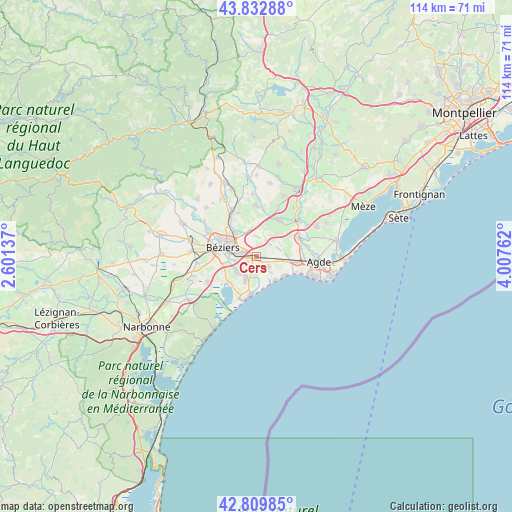
Cers GPS coordinates[2]
43° 19' 24.672" North, 3° 18' 16.2" East
| Map corner | latitude | longitude |
|---|---|---|
| Upper-left | 43.83288°, | 2.60137° |
| Center: | 43.32352°, | 3.3045° |
| Lower-right: | 42.80985°, | 4.00762° |
| Map W x H: | 113.8×113.7 km | = 70.7×70.6mi |
| max Lat: | 51.07786° ⇑95.2% North |
| Cers: | 43.32352° |
| min Lat: | ⇓4.8% South 41.3874° |
| min Long | Cers | max Long |
| -5.08615° | 3.3045° | 9.52242° |
| W 62.1%⇐ | ⇒37.9% E |
Elevation
Elevation of Cers is 12 m = 39 ft, and this is 181.7 m = 596 ft below average elevation for this country.
| Max E: |
2333 m = 7654 ft | 96.7% |
| Avg. | 193.7 m = 635 ft | |
| Cers | 12 m = 39 ft | |
Min E: |
-1 m = -3 ft | 3.3% |
See also: France elevation on elevation.city.
Geographical zone
Cers is located in North temperate zone (between Tropic of Cancer and the Arctic Circle). Distance of this Northern Tropic circle is 2211.2 km =1374 mi to South.| Distance of | km | miles | from Cers |
|---|---|---|---|
| North Pole | 5189.9 | 3224.9 | to North |
| Arctic Circle | 2584.1 | 1605.7 | to North |
| Tropic Cancer | 2211.2 | 1374 | to South |
| Equator | 4817.1 | 2993.2 | to South |


Nearby cities:
15 places around Cers: (largest is in red/bold)
• Bassan
10.5 km =6.5 mi,  337°
337°
• Bessan
10.5 km =6.5 mi,  65°
65°
• Boujan-sur-Libron
6.9 km =4.3 mi,  318°
318°
• Béziers
7.6 km =4.7 mi,  285°
285°
• Lieuran-lès-Béziers
11.9 km =7.4 mi,  332°
332°
• Montblanc
9.4 km =5.8 mi,  32°
32°
• Portiragnes
3.2 km =2 mi,  131°
131°
• Sauvian
4.9 km =3 mi,  226°
226°
• Servian
11.5 km =7.1 mi,  358°
358°
• Sérignan
5.5 km =3.4 mi,  203°
203°
• Valras-Plage
8.5 km =5.3 mi,  187°
187°
• Valros
11.7 km =7.3 mi,  24°
24°
• Vendres
8.9 km =5.5 mi, 227°
• Vias
9.3 km =5.8 mi,  98°
98°
• Villeneuve-lès-Béziers
2.1 km =1.3 mi,  244°
244°
Sources, notices
• [Note1] Compared only with cities in France existing in our database
• [Src1] Map data: © OpenStreetMap contributors (CC-BY-SA)
• [Src2] Other city data from geonames.org with taken over terms of usage.
• [Src3] Geographical zone / Annual Mean Temperature by Robert A. Rohde @ Wikipedia
