Boujan-sur-Libron geodata
Boujan-sur-Libron (Occitanie) is a populated place; located in France in Europe/Paris (GMT+2) time zone. With population of 3,011 people, there are 3241 cities with bigger population in this country. Compared to other cities in France, 94.6% of cities are located further ↑North; 61.3% of cities are located further ←West and 76.2% of cities have higher elevation than Boujan-sur-Libron. Note1
Administrative division(s):
- Level 1: Occitanie
- Level 2: Département de l'Hérault
- Level 3: Arrondissement de Béziers
- Level 4: Boujan-sur-Libron


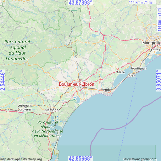
Boujan-sur-Libron GPS coordinates[2]
43° 22' 11.856" North, 3° 14' 51.324" East
| Map corner | latitude | longitude |
|---|---|---|
| Upper-left | 43.87893°, | 2.54446° |
| Center: | 43.36996°, | 3.24759° |
| Lower-right: | 42.85668°, | 3.95071° |
| Map W x H: | 113.7×113.7 km | = 70.6×70.6mi |
| max Lat: | 51.07786° ⇑94.6% North |
| Boujan-sur-Libron: | 43.36996° |
| min Lat: | ⇓5.4% South 41.3874° |
| min Long | Boujan-sur-Libr | max Long |
| -5.08615° | 3.24759° | 9.52242° |
| W 61.3%⇐ | ⇒38.7% E |
Elevation
Elevation of Boujan-sur-Libron is 64 m = 210 ft, and this is 129.7 m = 426 ft below average elevation for this country.
| Max E: |
2333 m = 7654 ft | 76.2% |
| Avg. | 193.7 m = 635 ft | |
| Boujan-sur-Libron | 64 m = 210 ft | |
Min E: |
-1 m = -3 ft | 23.8% |
See also: France elevation on elevation.city.
Geographical zone
Boujan-sur-Libron is located in North temperate zone (between Tropic of Cancer and the Arctic Circle). Distance of this Northern Tropic circle is 2216.4 km =1377.2 mi to South.| Distance of | km | miles | from Boujan-sur-Libron |
|---|---|---|---|
| North Pole | 5184.8 | 3221.7 | to North |
| Arctic Circle | 2578.9 | 1602.5 | to North |
| Tropic Cancer | 2216.4 | 1377.2 | to South |
| Equator | 4822.3 | 2996.4 | to South |


Nearby cities:
15 places around Boujan-sur-Libron: (largest is in red/bold)
• Abeilhan
9.6 km =6 mi,  23°
23°
• Bassan
4.5 km =2.8 mi,  6°
6°
• Béziers
4.2 km =2.6 mi,  220°
220°
• Cers
6.9 km =4.3 mi,  138°
138°
• Corneilhan
5.6 km =3.5 mi,  305°
305°
• Espondeilhan
8 km =5 mi, 9°
• Lieuran-lès-Béziers
5.5 km =3.4 mi,  351°
351°
• Lignan-sur-Orb
6.6 km =4.1 mi,  284°
284°
• Maraussan
7.4 km =4.6 mi,  269°
269°
• Pailhès
8.4 km =5.2 mi,  323°
323°
• Puimisson
8.3 km =5.2 mi,  335°
335°
• Sauvian
8.6 km =5.3 mi,  173°
173°
• Servian
7.7 km =4.8 mi,  33°
33°
• Thézan-lès-Béziers
8.3 km =5.2 mi, 308°
• Villeneuve-lès-Béziers
6.7 km =4.2 mi,  156°
156°
Sources, notices
• [Note1] Compared only with cities in France existing in our database
• [Src1] Map data: © OpenStreetMap contributors (CC-BY-SA)
• [Src2] Other city data from geonames.org with taken over terms of usage.
• [Src3] Geographical zone / Annual Mean Temperature by Robert A. Rohde @ Wikipedia
