Bassan geodata
Bassan (Occitanie) is a populated place; located in France in Europe/Paris (GMT+2) time zone. With population of 1,660 people, there are 5636 cities with bigger population in this country. Compared to other cities in France, 94.1% of cities are located further ↑North; 61.4% of cities are located further ←West and 65.6% of cities have higher elevation than Bassan. Note1
Administrative division(s):
- Level 1: Occitanie
- Level 2: Département de l'Hérault
- Level 3: Arrondissement de Béziers
- Level 4: Bassan


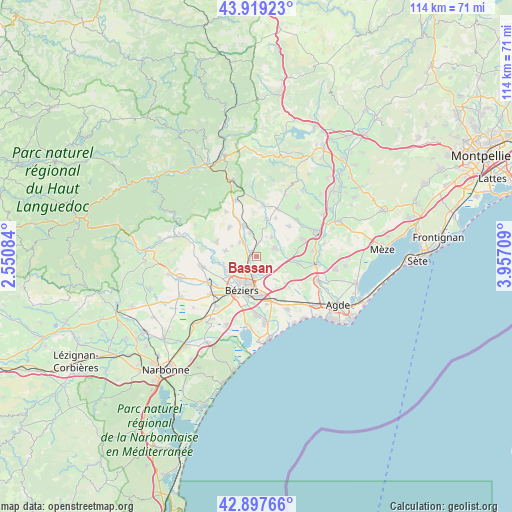
Bassan GPS coordinates[2]
43° 24' 38.16" North, 3° 15' 14.256" East
| Map corner | latitude | longitude |
|---|---|---|
| Upper-left | 43.91923°, | 2.55084° |
| Center: | 43.4106°, | 3.25396° |
| Lower-right: | 42.89766°, | 3.95709° |
| Map W x H: | 113.6×113.6 km | = 70.6×70.6mi |
| max Lat: | 51.07786° ⇑94.1% North |
| Bassan: | 43.4106° |
| min Lat: | ⇓5.9% South 41.3874° |
| min Long | Bassan | max Long |
| -5.08615° | 3.25396° | 9.52242° |
| W 61.4%⇐ | ⇒38.6% E |
Elevation
Elevation of Bassan is 88 m = 289 ft, and this is 105.7 m = 347 ft below average elevation for this country.
| Max E: |
2333 m = 7654 ft | 65.6% |
| Avg. | 193.7 m = 635 ft | |
| Bassan | 88 m = 289 ft | |
Min E: |
-1 m = -3 ft | 34.4% |
See also: France elevation on elevation.city.
Geographical zone
Bassan is located in North temperate zone (between Tropic of Cancer and the Arctic Circle). Distance of this Northern Tropic circle is 2220.9 km =1380 mi to South.| Distance of | km | miles | from Bassan |
|---|---|---|---|
| North Pole | 5180.3 | 3218.9 | to North |
| Arctic Circle | 2574.4 | 1599.7 | to North |
| Tropic Cancer | 2220.9 | 1380 | to South |
| Equator | 4826.8 | 2999.2 | to South |


Nearby cities:
15 places around Bassan: (largest is in red/bold)
• Abeilhan
5.4 km =3.4 mi,  37°
37°
• Boujan-sur-Libron
4.5 km =2.8 mi,  186°
186°
• Béziers
8.4 km =5.2 mi,  202°
202°
• Corneilhan
5.2 km =3.2 mi,  256°
256°
• Espondeilhan
3.5 km =2.2 mi,  13°
13°
• Lieuran-lès-Béziers
1.6 km =1 mi,  303°
303°
• Lignan-sur-Orb
7.5 km =4.7 mi,  247°
247°
• Magalas
7.2 km =4.5 mi,  339°
339°
• Pailhès
6 km =3.7 mi,  291°
291°
• Pouzolles
8.3 km =5.2 mi, 14°
• Puimisson
4.9 km =3 mi,  307°
307°
• Puissalicon
5.5 km =3.4 mi,  345°
345°
• Saint-Geniès-de-Fontedit
8.4 km =5.2 mi,  317°
317°
• Servian
4.2 km =2.6 mi,  63°
63°
• Thézan-lès-Béziers
7.1 km =4.4 mi,  275°
275°
Sources, notices
• [Note1] Compared only with cities in France existing in our database
• [Src1] Map data: © OpenStreetMap contributors (CC-BY-SA)
• [Src2] Other city data from geonames.org with taken over terms of usage.
• [Src3] Geographical zone / Annual Mean Temperature by Robert A. Rohde @ Wikipedia
