Cazals geodata
Cazals (Occitanie) is a populated place; located in France in Europe/Paris (GMT+2) time zone. With population of 613 people, there are 13109 cities with bigger population in this country. Compared to other cities in France, 82.5% of cities are located further ↑North; 66.4% of cities are located further →East and 62.7% of cities have lower elevation than Cazals. Note1
Administrative division(s):
- Level 1: Occitanie
- Level 2: Lot
- Level 3: Arrondissement de Gourdon
- Level 4: Cazals


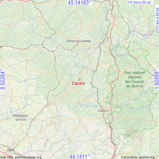
Cazals GPS coordinates[2]
44° 38' 36.672" North, 1° 13' 32.736" East
| Map corner | latitude | longitude |
|---|---|---|
| Upper-left | 45.14163°, | 0.52264° |
| Center: | 44.64352°, | 1.22576° |
| Lower-right: | 44.1411°, | 1.92889° |
| Map W x H: | 111.2×111.2 km | = 69.1×69.1mi |
| max Lat: | 51.07786° ⇑82.5% North |
| Cazals: | 44.64352° |
| min Lat: | ⇓17.5% South 41.3874° |
| min Long | Cazals | max Long |
| -5.08615° | 1.22576° | 9.52242° |
| W 33.6%⇐ | ⇒66.4% E |
Elevation
Elevation of Cazals is 183 m = 600 ft, and this is 10.7 m = 35 ft below average elevation for this country.
| Max E: |
2333 m = 7654 ft | 37.3% |
| Avg. | 193.7 m = 635 ft | |
| Cazals | 183 m = 600 ft | |
Min E: |
-1 m = -3 ft | 62.7% |
See also: France elevation on elevation.city.
Geographical zone
Cazals is located in North temperate zone (between Tropic of Cancer and the Arctic Circle). Distance of this Northern Tropic circle is 2358 km =1465.2 mi to South.| Distance of | km | miles | from Cazals |
|---|---|---|---|
| North Pole | 5043.2 | 3133.7 | to North |
| Arctic Circle | 2437.3 | 1514.5 | to North |
| Tropic Cancer | 2358 | 1465.2 | to South |
| Equator | 4963.9 | 3084.4 | to South |


Nearby cities:
15 places around Cazals: (largest is in red/bold)
• Catus
13 km =8.1 mi,  137°
137°
• Cénac-et-Saint-Julien
17.4 km =10.8 mi,  354°
354°
• Daglan
11.3 km =7 mi, 346°
• Domme
17.7 km =11 mi,  357°
357°
• Duravel
18.3 km =11.4 mi,  219°
219°
• Dégagnac
7.5 km =4.7 mi,  71°
71°
• Gourdon
16.2 km =10.1 mi,  49°
49°
• Payrignac
15.9 km =9.9 mi,  38°
38°
• Prayssac
15.7 km =9.8 mi,  190°
190°
• Puy-l’Évêque
16.8 km =10.4 mi,  203°
203°
• Saint-Germain-du-Bel-Air
17 km =10.6 mi,  88°
88°
• Saint-Martial-de-Nabirat
11.5 km =7.1 mi,  12°
12°
• Salviac
5.2 km =3.2 mi, 36°
• Sauveterre-la-Lémance
18 km =11.2 mi,  250°
250°
• Villefranche-du-Périgord
11.6 km =7.2 mi,  262°
262°
Sources, notices
• [Note1] Compared only with cities in France existing in our database
• [Src1] Map data: © OpenStreetMap contributors (CC-BY-SA)
• [Src2] Other city data from geonames.org with taken over terms of usage.
• [Src3] Geographical zone / Annual Mean Temperature by Robert A. Rohde @ Wikipedia
