Saint-Germain-du-Bel-Air geodata
Saint-Germain-du-Bel-Air (Occitanie) is a populated place; located in France in Europe/Paris (GMT+2) time zone. With population of 533 people, there are 14546 cities with bigger population in this country. Compared to other cities in France, 82.5% of cities are located further ↑North; 63.8% of cities are located further →East and 70.4% of cities have lower elevation than Saint-Germain-du-Bel-Air. Note1
Administrative division(s):
- Level 1: Occitanie
- Level 2: Lot
- Level 3: Arrondissement de Gourdon
- Level 4: Saint-Germain-du-Bel-Air
Current local time in Saint-Germain-du-Bel-Air:
02:30 PM, SaturdayDifference from your time zone: hours


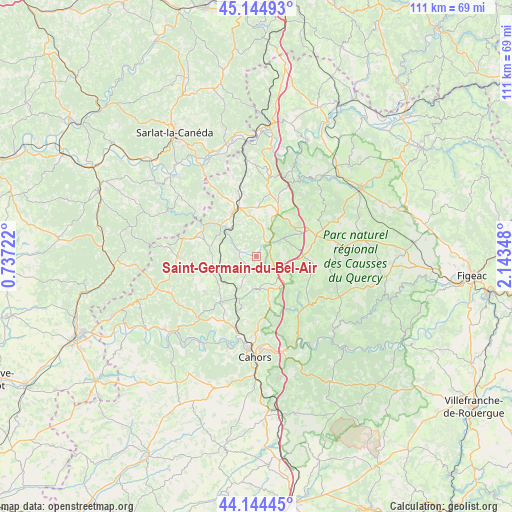
Saint-Germain-du-Bel-Air GPS coordinates[2]
44° 38' 48.66" North, 1° 26' 25.26" East
| Map corner | latitude | longitude |
|---|---|---|
| Upper-left | 45.14493°, | 0.73722° |
| Center: | 44.64685°, | 1.44035° |
| Lower-right: | 44.14445°, | 2.14348° |
| Map W x H: | 111.2×111.2 km | = 69.1×69.1mi |
| max Lat: | 51.07786° ⇑82.5% North |
| Saint-Germain-du-Bel-Air: | 44.64685° |
| min Lat: | ⇓17.5% South 41.3874° |
| min Long | Saint-Germain-d | max Long |
| -5.08615° | 1.44035° | 9.52242° |
| W 36.2%⇐ | ⇒63.8% E |
Elevation
Elevation of Saint-Germain-du-Bel-Air is 221 m = 725 ft, and this is 27.3 m = 90 ft above average elevation for this country.
| Max E: |
2333 m = 7654 ft | 29.6% |
| Saint-Germain-du-Bel-Air | 221 m 725 ft | |
| Avg. | 193.7 m = 635 ft | |
Min E: |
-1 m = -3 ft | 70.4% |
See also: France elevation on elevation.city.
Geographical zone
Saint-Germain-du-Bel-Air is located in North temperate zone (between Tropic of Cancer and the Arctic Circle). Distance of this Northern Tropic circle is 2358.3 km =1465.4 mi to South.| Distance of | km | miles | from Saint-Germain-du-Bel-Air |
|---|---|---|---|
| North Pole | 5042.8 | 3133.4 | to North |
| Arctic Circle | 2436.9 | 1514.2 | to North |
| Tropic Cancer | 2358.3 | 1465.4 | to South |
| Equator | 4964.3 | 3084.7 | to South |


Nearby cities:
15 places around Saint-Germain-du-Bel-Air: (largest is in red/bold)
• Caillac
18.7 km =11.6 mi,  201°
201°
• Catus
13 km =8.1 mi,  219°
219°
• Cazals
17 km =10.6 mi,  268°
268°
• Dégagnac
10.1 km =6.3 mi,  281°
281°
• Espère
16.1 km =10 mi, 199°
• Gourdon
11 km =6.8 mi,  335°
335°
• Labastide-Murat
10.1 km =6.3 mi,  89°
89°
• Le Vigan
10.4 km =6.5 mi,  359°
359°
• Mercuès
17.2 km =10.7 mi,  194°
194°
• Montfaucon
10.6 km =6.6 mi,  64°
64°
• Payrac
16.8 km =10.4 mi,  8°
8°
• Payrignac
13.9 km =8.6 mi,  329°
329°
• Pradines
18.4 km =11.4 mi, 189°
• Saint-Martial-de-Nabirat
18 km =11.2 mi,  307°
307°
• Salviac
14.4 km =8.9 mi,  285°
285°
Sources, notices
• [Note1] Compared only with cities in France existing in our database
• [Src1] Map data: © OpenStreetMap contributors (CC-BY-SA)
• [Src2] Other city data from geonames.org with taken over terms of usage.
• [Src3] Geographical zone / Annual Mean Temperature by Robert A. Rohde @ Wikipedia
