Castelnau-de-Guers geodata
Castelnau-de-Guers (Occitanie) is a populated place; located in France in Europe/Paris (GMT+2) time zone. With population of 1,013 people, there are 8749 cities with bigger population in this country. Compared to other cities in France, 93.9% of cities are located further ↑North; 63.6% of cities are located further ←West and 86.7% of cities have higher elevation than Castelnau-de-Guers. Note1
Administrative division(s):
- Level 1: Occitanie
- Level 2: Département de l'Hérault
- Level 3: Arrondissement de Béziers
- Level 4: Castelnau-de-Guers


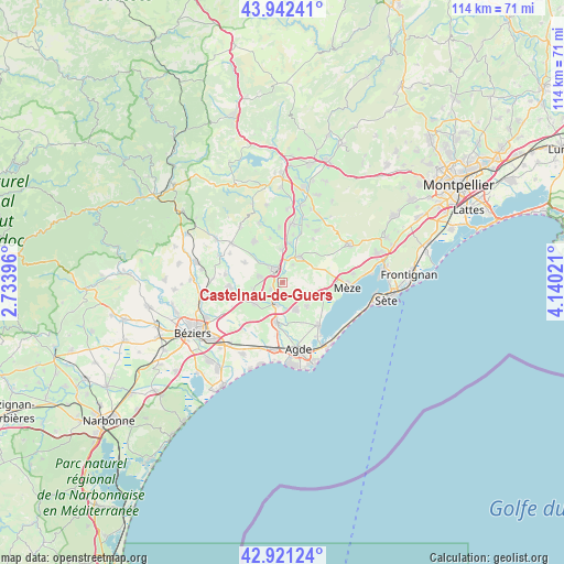
Castelnau-de-Guers GPS coordinates[2]
43° 26' 2.328" North, 3° 26' 13.488" East
| Map corner | latitude | longitude |
|---|---|---|
| Upper-left | 43.94241°, | 2.73396° |
| Center: | 43.43398°, | 3.43708° |
| Lower-right: | 42.92124°, | 4.14021° |
| Map W x H: | 113.5×113.5 km | = 70.5×70.5mi |
| max Lat: | 51.07786° ⇑93.9% North |
| Castelnau-de-Guers: | 43.43398° |
| min Lat: | ⇓6.1% South 41.3874° |
| min Long | Castelnau-de-Gu | max Long |
| -5.08615° | 3.43708° | 9.52242° |
| W 63.6%⇐ | ⇒36.4% E |
Elevation
Elevation of Castelnau-de-Guers is 38 m = 125 ft, and this is 155.7 m = 511 ft below average elevation for this country.
| Max E: |
2333 m = 7654 ft | 86.7% |
| Avg. | 193.7 m = 635 ft | |
| Castelnau-de-Guers | 38 m = 125 ft | |
Min E: |
-1 m = -3 ft | 13.3% |
See also: France elevation on elevation.city.
Geographical zone
Castelnau-de-Guers is located in North temperate zone (between Tropic of Cancer and the Arctic Circle). Distance of this Northern Tropic circle is 2223.5 km =1381.6 mi to South.| Distance of | km | miles | from Castelnau-de-Guers |
|---|---|---|---|
| North Pole | 5177.7 | 3217.3 | to North |
| Arctic Circle | 2571.8 | 1598 | to North |
| Tropic Cancer | 2223.5 | 1381.6 | to South |
| Equator | 4829.4 | 3000.8 | to South |


Nearby cities:
15 places around Castelnau-de-Guers: (largest is in red/bold)
• Alignan-du-Vent
8.7 km =5.4 mi,  297°
297°
• Bessan
8.1 km =5 mi,  188°
188°
• Caux
9.8 km =6.1 mi,  324°
324°
• Florensac
6.1 km =3.8 mi,  157°
157°
• Lézignan-la-Cèbe
6.6 km =4.1 mi,  0°
0°
• Montagnac
6.4 km =4 mi,  35°
35°
• Montblanc
7.1 km =4.4 mi,  232°
232°
• Nizas
9.1 km =5.7 mi,  345°
345°
• Pinet
6.7 km =4.2 mi,  118°
118°
• Pomérols
6.9 km =4.3 mi,  133°
133°
• Pézenas
3 km =1.9 mi,  339°
339°
• Saint-Pons-de-Mauchiens
10.8 km =6.7 mi, 35°
• Saint-Thibéry
4.4 km =2.7 mi,  200°
200°
• Tourbes
4.9 km =3 mi,  285°
285°
• Valros
6 km =3.7 mi,  254°
254°
Sources, notices
• [Note1] Compared only with cities in France existing in our database
• [Src1] Map data: © OpenStreetMap contributors (CC-BY-SA)
• [Src2] Other city data from geonames.org with taken over terms of usage.
• [Src3] Geographical zone / Annual Mean Temperature by Robert A. Rohde @ Wikipedia
