Pézenas geodata
Pézenas (Occitanie) is a populated place; located in France in Europe/Paris (GMT+2) time zone. With population of 8,647 people, there are 1111 cities with bigger population in this country. Compared to other cities in France, 93.6% of cities are located further ↑North; 63.5% of cities are located further ←West and 91.2% of cities have higher elevation than Pézenas. Note1
Administrative division(s):
- Level 1: Occitanie
- Level 2: Département de l'Hérault
- Level 3: Arrondissement de Béziers
- Level 4: Pézenas


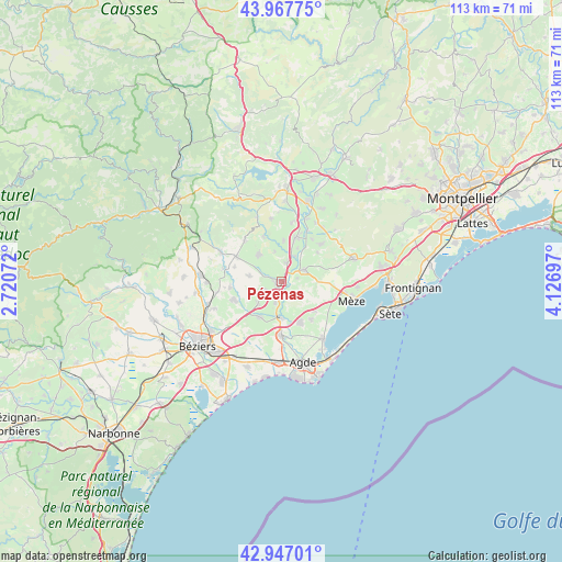
Pézenas GPS coordinates[2]
43° 27' 34.308" North, 3° 25' 25.824" East
| Map corner | latitude | longitude |
|---|---|---|
| Upper-left | 43.96775°, | 2.72072° |
| Center: | 43.45953°, | 3.42384° |
| Lower-right: | 42.94701°, | 4.12697° |
| Map W x H: | 113.5×113.5 km | = 70.5×70.5mi |
| max Lat: | 51.07786° ⇑93.6% North |
| Pézenas: | 43.45953° |
| min Lat: | ⇓6.4% South 41.3874° |
| min Long | Pézenas | max Long |
| -5.08615° | 3.42384° | 9.52242° |
| W 63.5%⇐ | ⇒36.5% E |
Elevation
Elevation of Pézenas is 27 m = 89 ft, and this is 166.7 m = 547 ft below average elevation for this country.
| Max E: |
2333 m = 7654 ft | 91.2% |
| Avg. | 193.7 m = 635 ft | |
| Pézenas | 27 m = 89 ft | |
Min E: |
-1 m = -3 ft | 8.8% |
See also: France elevation on elevation.city.
Geographical zone
Pézenas is located in North temperate zone (between Tropic of Cancer and the Arctic Circle). Distance of this Northern Tropic circle is 2226.3 km =1383.4 mi to South.| Distance of | km | miles | from Pézenas |
|---|---|---|---|
| North Pole | 5174.8 | 3215.5 | to North |
| Arctic Circle | 2568.9 | 1596.2 | to North |
| Tropic Cancer | 2226.3 | 1383.4 | to South |
| Equator | 4832.2 | 3002.6 | to South |


Nearby cities:
15 places around Pézenas: (largest is in red/bold)
• Adissan
8.3 km =5.2 mi,  1°
1°
• Alignan-du-Vent
6.7 km =4.2 mi,  279°
279°
• Castelnau-de-Guers
3 km =1.9 mi,  159°
159°
• Caux
6.9 km =4.3 mi,  318°
318°
• Florensac
9.2 km =5.7 mi, 158°
• Lézignan-la-Cèbe
3.9 km =2.4 mi,  15°
15°
• Montagnac
5.3 km =3.3 mi,  63°
63°
• Montblanc
8.5 km =5.3 mi,  212°
212°
• Nizas
6.1 km =3.8 mi,  347°
347°
• Paulhan
9.3 km =5.8 mi, 17°
• Pinet
9.2 km =5.7 mi,  130°
130°
• Saint-Pons-de-Mauchiens
9.4 km =5.8 mi,  51°
51°
• Saint-Thibéry
7 km =4.3 mi,  184°
184°
• Tourbes
3.9 km =2.4 mi,  247°
247°
• Valros
6.5 km =4 mi,  226°
226°
Sources, notices
• [Note1] Compared only with cities in France existing in our database
• [Src1] Map data: © OpenStreetMap contributors (CC-BY-SA)
• [Src2] Other city data from geonames.org with taken over terms of usage.
• [Src3] Geographical zone / Annual Mean Temperature by Robert A. Rohde @ Wikipedia
