Monclar geodata
Monclar (Nouvelle-Aquitaine) is a populated place; located in France in Europe/Paris (GMT+2) time zone. With population of 921 people, there are 9479 cities with bigger population in this country. Compared to other cities in France, 83.9% of cities are located further ↑North; 73.1% of cities are located further →East and 55.2% of cities have higher elevation than Monclar. Note1
Administrative division(s):
- Level 1: Nouvelle-Aquitaine
- Level 2: Département du Lot-et-Garonne
- Level 3: Arrondissement de Villeneuve-sur-Lot
- Level 4: Monclar


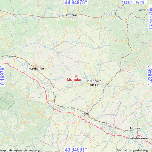
Monclar GPS coordinates[2]
44° 27' 0" North, 0° 31' 59.988" East
| Map corner | latitude | longitude |
|---|---|---|
| Upper-left | 44.94978°, | -0.16979° |
| Center: | 44.45°, | 0.53333° |
| Lower-right: | 43.94591°, | 1.23646° |
| Map W x H: | 111.6×111.6 km | = 69.3×69.3mi |
| max Lat: | 51.07786° ⇑83.9% North |
| Monclar: | 44.45° |
| min Lat: | ⇓16.1% South 41.3874° |
| min Long | Monclar | max Long |
| -5.08615° | 0.53333° | 9.52242° |
| W 26.9%⇐ | ⇒73.1% E |
Elevation
Elevation of Monclar is 116 m = 381 ft, and this is 77.7 m = 255 ft below average elevation for this country.
| Max E: |
2333 m = 7654 ft | 55.2% |
| Avg. | 193.7 m = 635 ft | |
| Monclar | 116 m = 381 ft | |
Min E: |
-1 m = -3 ft | 44.8% |
See also: France elevation on elevation.city.
Geographical zone
Monclar is located in North temperate zone (between Tropic of Cancer and the Arctic Circle). Distance of this Northern Tropic circle is 2336.5 km =1451.8 mi to South.| Distance of | km | miles | from Monclar |
|---|---|---|---|
| North Pole | 5064.7 | 3147.1 | to North |
| Arctic Circle | 2458.8 | 1527.8 | to North |
| Tropic Cancer | 2336.5 | 1451.8 | to South |
| Equator | 4942.4 | 3071.1 | to South |


Nearby cities:
15 places around Monclar: (largest is in red/bold)
• Allez-et-Cazeneuve
8.6 km =5.3 mi,  130°
130°
• Bias
11.5 km =7.1 mi,  108°
108°
• Cancon
12 km =7.5 mi,  37°
37°
• Casseneuil
7 km =4.3 mi,  96°
96°
• Castelmoron-sur-Lot
6.5 km =4 mi,  207°
207°
• Castelnaud-de-Gratecambe
11.9 km =7.4 mi,  64°
64°
• Dolmayrac
10.7 km =6.6 mi,  155°
155°
• Granges-sur-Lot
9.8 km =6.1 mi, 213°
• Le Temple-sur-Lot
7.9 km =4.9 mi,  184°
184°
• Lédat
10.8 km =6.7 mi,  88°
88°
• Monbahus
10.9 km =6.8 mi,  0°
0°
• Montpezat
11.4 km =7.1 mi, 184°
• Pinel-Hauterive
4.4 km =2.7 mi,  120°
120°
• Saint-Étienne-de-Fougères
3.9 km =2.4 mi,  153°
153°
• Sainte-Livrade-sur-Lot
7.3 km =4.5 mi,  140°
140°
Sources, notices
• [Note1] Compared only with cities in France existing in our database
• [Src1] Map data: © OpenStreetMap contributors (CC-BY-SA)
• [Src2] Other city data from geonames.org with taken over terms of usage.
• [Src3] Geographical zone / Annual Mean Temperature by Robert A. Rohde @ Wikipedia
