Castellane geodata
Castellane (Provence-Alpes-Côte d'Azur) is a seat of a third-order administrative division; located in France in Europe/Paris (GMT+2) time zone. With population of 1,612 people, there are 5797 cities with bigger population in this country. Compared to other cities in France, 88.6% of cities are located further ↑North; 91.8% of cities are located further ←West and 97.9% of cities have lower elevation than Castellane. Note1
Administrative division(s):
- Level 1: Provence-Alpes-Côte d'Azur
- Level 2: Alpes-de-Haute-Provence
- Level 3: Arrondissement de Castellane
- Level 4: Castellane


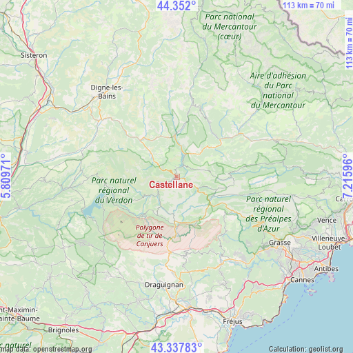
Castellane GPS coordinates[2]
43° 50' 49.452" North, 6° 30' 46.188" East
| Map corner | latitude | longitude |
|---|---|---|
| Upper-left | 44.352°, | 5.80971° |
| Center: | 43.84707°, | 6.51283° |
| Lower-right: | 43.33783°, | 7.21596° |
| Map W x H: | 112.8×112.8 km | = 70.1×70.1mi |
| max Lat: | 51.07786° ⇑88.6% North |
| Castellane: | 43.84707° |
| min Lat: | ⇓11.4% South 41.3874° |
| min Long | Castellane | max Long |
| -5.08615° | 6.51283° | 9.52242° |
| W 91.8%⇐ | ⇒8.2% E |
Elevation
Elevation of Castellane is 806 m = 2644 ft, and this is 612.3 m = 2009 ft above average elevation for this country.
| Max E: |
2333 m = 7654 ft | 2.1% |
| Castellane | 806 m 2644 ft | |
| Avg. | 193.7 m = 635 ft | |
Min E: |
-1 m = -3 ft | 97.9% |
See also: France elevation on elevation.city.
Geographical zone
Castellane is located in North temperate zone (between Tropic of Cancer and the Arctic Circle). Distance of this Northern Tropic circle is 2269.4 km =1410.1 mi to South.| Distance of | km | miles | from Castellane |
|---|---|---|---|
| North Pole | 5131.7 | 3188.7 | to North |
| Arctic Circle | 2525.8 | 1569.5 | to North |
| Tropic Cancer | 2269.4 | 1410.1 | to South |
| Equator | 4875.3 | 3029.4 | to South |


Nearby cities:
15 places around Castellane: (largest is in red/bold)
• Ampus
28.7 km =17.8 mi,  201°
201°
• Annot
18.1 km =11.2 mi,  43°
43°
• Bargemon
25.5 km =15.8 mi,  173°
173°
• Barrême
16.5 km =10.3 mi,  315°
315°
• Callas
28.3 km =17.6 mi,  175°
175°
• Claviers
27.6 km =17.1 mi, 171°
• Entrevaux
26.4 km =16.4 mi,  64°
64°
• Fayence
28.6 km =17.8 mi,  149°
149°
• Mons
23.7 km =14.7 mi,  137°
137°
• Montferrat
26.3 km =16.3 mi,  185°
185°
• Moustiers-Sainte-Marie
23.3 km =14.5 mi,  269°
269°
• Mézel
30.3 km =18.8 mi,  303°
303°
• Roumoules
30.8 km =19.1 mi, 265°
• Saint-André-les-Alpes
13.5 km =8.4 mi,  358°
358°
• Seillans
25.7 km =16 mi,  155°
155°
Sources, notices
• [Note1] Compared only with cities in France existing in our database
• [Src1] Map data: © OpenStreetMap contributors (CC-BY-SA)
• [Src2] Other city data from geonames.org with taken over terms of usage.
• [Src3] Geographical zone / Annual Mean Temperature by Robert A. Rohde @ Wikipedia
