Annot geodata
Annot (Provence-Alpes-Côte d'Azur) is a populated place; located in France in Europe/Paris (GMT+2) time zone. With population of 1,073 people, there are 8312 cities with bigger population in this country. Compared to other cities in France, 87.4% of cities are located further ↑North; 92.8% of cities are located further ←West and 98.3% of cities have lower elevation than Annot. Note1
Administrative division(s):
- Level 1: Provence-Alpes-Côte d'Azur
- Level 2: Alpes-de-Haute-Provence
- Level 3: Arrondissement de Castellane
- Level 4: Annot


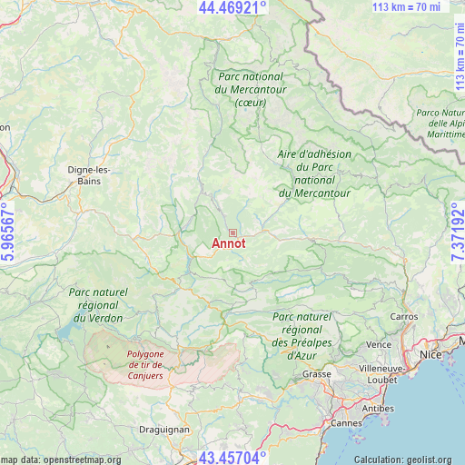
Annot GPS coordinates[2]
43° 57' 55.008" North, 6° 40' 7.644" East
| Map corner | latitude | longitude |
|---|---|---|
| Upper-left | 44.46921°, | 5.96567° |
| Center: | 43.96528°, | 6.66879° |
| Lower-right: | 43.45704°, | 7.37192° |
| Map W x H: | 112.5×112.5 km | = 69.9×69.9mi |
| max Lat: | 51.07786° ⇑87.4% North |
| Annot: | 43.96528° |
| min Lat: | ⇓12.6% South 41.3874° |
| min Long | Annot | max Long |
| -5.08615° | 6.66879° | 9.52242° |
| W 92.8%⇐ | ⇒7.2% E |
Elevation
Elevation of Annot is 857 m = 2812 ft, and this is 663.3 m = 2176 ft above average elevation for this country.
| Max E: |
2333 m = 7654 ft | 1.7% |
| Annot | 857 m 2812 ft | |
| Avg. | 193.7 m = 635 ft | |
Min E: |
-1 m = -3 ft | 98.3% |
See also: France elevation on elevation.city.
Geographical zone
Annot is located in North temperate zone (between Tropic of Cancer and the Arctic Circle). Distance of this Northern Tropic circle is 2282.6 km =1418.3 mi to South.| Distance of | km | miles | from Annot |
|---|---|---|---|
| North Pole | 5118.6 | 3180.5 | to North |
| Arctic Circle | 2512.7 | 1561.3 | to North |
| Tropic Cancer | 2282.6 | 1418.3 | to South |
| Equator | 4888.5 | 3037.6 | to South |


Nearby cities:
15 places around Annot: (largest is in red/bold)
• Allos
30.8 km =19.1 mi,  354°
354°
• Barrême
24.1 km =15 mi,  266°
266°
• Castellane
18.1 km =11.2 mi,  223°
223°
• Entrevaux
11.5 km =7.1 mi,  98°
98°
• Guillaumes
20.3 km =12.6 mi,  46°
46°
• Le Brusquet
36.1 km =22.4 mi,  307°
307°
• Mons
30.7 km =19.1 mi,  173°
173°
• Puget-Théniers
18 km =11.2 mi,  93°
93°
• Péone
25.4 km =15.8 mi, 48°
• Roquesteron
28.7 km =17.8 mi,  112°
112°
• Saint-André-les-Alpes
12.9 km =8 mi, 271°
• Saint-Cézaire-sur-Siagne
36.4 km =22.6 mi,  164°
164°
• Saint-Vallier-de-Thiey
33 km =20.5 mi,  154°
154°
• Seillans
36.6 km =22.7 mi,  183°
183°
• Villars-sur-Var
34.4 km =21.4 mi, 95°
Sources, notices
• [Note1] Compared only with cities in France existing in our database
• [Src1] Map data: © OpenStreetMap contributors (CC-BY-SA)
• [Src2] Other city data from geonames.org with taken over terms of usage.
• [Src3] Geographical zone / Annual Mean Temperature by Robert A. Rohde @ Wikipedia
