Cassis geodata
Cassis (Provence-Alpes-Côte d'Azur) is a populated place; located in France in Europe/Paris (GMT+2) time zone. With population of 8,361 people, there are 1158 cities with bigger population in this country. Compared to other cities in France, 97% of cities are located further ↑North; 83.2% of cities are located further ←West and 66.1% of cities have lower elevation than Cassis. Note1
Administrative division(s):
- Level 1: Provence-Alpes-Côte d'Azur
- Level 2: Département des Bouches-du-Rhône
- Level 3: Arrondissement de Marseille
- Level 4: Cassis


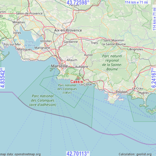
Cassis GPS coordinates[2]
43° 12' 56.556" North, 5° 32' 18.78" East
| Map corner | latitude | longitude |
|---|---|---|
| Upper-left | 43.72598°, | 4.83542° |
| Center: | 43.21571°, | 5.53855° |
| Lower-right: | 42.70113°, | 6.24167° |
| Map W x H: | 114×114 km | = 70.8×70.8mi |
| max Lat: | 51.07786° ⇑97% North |
| Cassis: | 43.21571° |
| min Lat: | ⇓3% South 41.3874° |
| min Long | Cassis | max Long |
| -5.08615° | 5.53855° | 9.52242° |
| W 83.2%⇐ | ⇒16.8% E |
Elevation
Elevation of Cassis is 199 m = 653 ft, and this is 5.3 m = 17 ft above average elevation for this country.
| Max E: |
2333 m = 7654 ft | 33.9% |
| Cassis | 199 m 653 ft | |
| Avg. | 193.7 m = 635 ft | |
Min E: |
-1 m = -3 ft | 66.1% |
See also: France elevation on elevation.city.
Geographical zone
Cassis is located in North temperate zone (between Tropic of Cancer and the Arctic Circle). Distance of this Northern Tropic circle is 2199.2 km =1366.5 mi to South.| Distance of | km | miles | from Cassis |
|---|---|---|---|
| North Pole | 5201.9 | 3232.3 | to North |
| Arctic Circle | 2596 | 1613.1 | to North |
| Tropic Cancer | 2199.2 | 1366.5 | to South |
| Equator | 4805.1 | 2985.7 | to South |


Nearby cities:
15 places around Cassis: (largest is in red/bold)
• Aubagne
9 km =5.6 mi,  16°
16°
• Carnoux-en-Provence
5 km =3.1 mi, 24°
• Ceyreste
7.4 km =4.6 mi,  91°
91°
• La Barasse
8.7 km =5.4 mi,  331°
331°
• La Ciotat
7 km =4.3 mi,  130°
130°
• La Millère
8 km =5 mi,  335°
335°
• La Panouse
9.9 km =6.2 mi,  296°
296°
• La Penne-sur-Huveaune
7.6 km =4.7 mi,  346°
346°
• Le Redon
9.5 km =5.9 mi,  290°
290°
• Roquefort-la-Bédoule
5.6 km =3.5 mi,  48°
48°
• Saint-Marcel
9.9 km =6.2 mi,  323°
323°
• Saint-Menet
8.7 km =5.4 mi, 341°
• Sormiou
9.7 km =6 mi,  265°
265°
• Vaufrège
8.6 km =5.3 mi, 295°
• Éoures
9.5 km =5.9 mi, 351°
Sources, notices
• [Note1] Compared only with cities in France existing in our database
• [Src1] Map data: © OpenStreetMap contributors (CC-BY-SA)
• [Src2] Other city data from geonames.org with taken over terms of usage.
• [Src3] Geographical zone / Annual Mean Temperature by Robert A. Rohde @ Wikipedia
