Ceyreste geodata
Ceyreste (Provence-Alpes-Côte d'Azur) is a populated place; located in France in Europe/Paris (GMT+2) time zone. With population of 3,798 people, there are 2584 cities with bigger population in this country. Compared to other cities in France, 97% of cities are located further ↑North; 83.9% of cities are located further ←West and 52.6% of cities have higher elevation than Ceyreste. Note1
Administrative division(s):
- Level 1: Provence-Alpes-Côte d'Azur
- Level 2: Département des Bouches-du-Rhône
- Level 3: Arrondissement de Marseille
- Level 4: Ceyreste


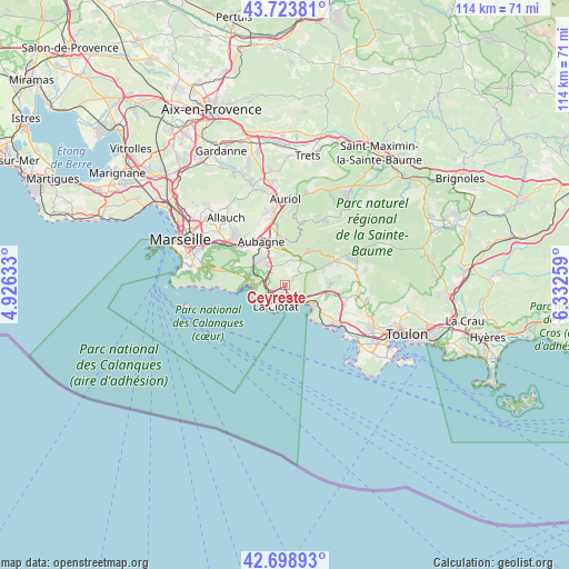
Ceyreste GPS coordinates[2]
43° 12' 48.672" North, 5° 37' 46.056" East
| Map corner | latitude | longitude |
|---|---|---|
| Upper-left | 43.72381°, | 4.92633° |
| Center: | 43.21352°, | 5.62946° |
| Lower-right: | 42.69893°, | 6.33259° |
| Map W x H: | 114×114 km | = 70.8×70.8mi |
| max Lat: | 51.07786° ⇑97% North |
| Ceyreste: | 43.21352° |
| min Lat: | ⇓3% South 41.3874° |
| min Long | Ceyreste | max Long |
| -5.08615° | 5.62946° | 9.52242° |
| W 83.9%⇐ | ⇒16.1% E |
Elevation
Elevation of Ceyreste is 123 m = 404 ft, and this is 70.7 m = 232 ft below average elevation for this country.
| Max E: |
2333 m = 7654 ft | 52.6% |
| Avg. | 193.7 m = 635 ft | |
| Ceyreste | 123 m = 404 ft | |
Min E: |
-1 m = -3 ft | 47.4% |
See also: France elevation on elevation.city.
Geographical zone
Ceyreste is located in North temperate zone (between Tropic of Cancer and the Arctic Circle). Distance of this Northern Tropic circle is 2199 km =1366.4 mi to South.| Distance of | km | miles | from Ceyreste |
|---|---|---|---|
| North Pole | 5202.2 | 3232.5 | to North |
| Arctic Circle | 2596.3 | 1613.3 | to North |
| Tropic Cancer | 2199 | 1366.4 | to South |
| Equator | 4804.9 | 2985.6 | to South |


Nearby cities:
15 places around Ceyreste: (largest is in red/bold)
• Aubagne
10 km =6.2 mi,  331°
331°
• Bandol
12.4 km =7.7 mi,  129°
129°
• Carnoux-en-Provence
7.1 km =4.4 mi,  312°
312°
• Cassis
7.4 km =4.6 mi,  271°
271°
• Cuges-les-Pins
9 km =5.6 mi,  39°
39°
• Gémenos
9.3 km =5.8 mi,  359°
359°
• La Ciotat
4.8 km =3 mi,  205°
205°
• La Millère
13 km =8.1 mi, 305°
• La Penne-sur-Huveaune
11.9 km =7.4 mi, 309°
• Le Castellet
12 km =7.5 mi,  95°
95°
• Les Camoins
13.7 km =8.5 mi,  318°
318°
• Roquefort-la-Bédoule
5.1 km =3.2 mi, 320°
• Saint-Cyr-sur-Mer
6.9 km =4.3 mi,  122°
122°
• Saint-Menet
13.2 km =8.2 mi, 309°
• Éoures
13 km =8.1 mi, 317°
Sources, notices
• [Note1] Compared only with cities in France existing in our database
• [Src1] Map data: © OpenStreetMap contributors (CC-BY-SA)
• [Src2] Other city data from geonames.org with taken over terms of usage.
• [Src3] Geographical zone / Annual Mean Temperature by Robert A. Rohde @ Wikipedia
