Faycelles geodata
Faycelles (Occitanie) is a populated place; located in France in Europe/Paris (GMT+2) time zone. With population of 580 people, there are 13652 cities with bigger population in this country. Compared to other cities in France, 83% of cities are located further ↑North; 57.3% of cities are located further →East and 83.2% of cities have lower elevation than Faycelles. Note1
Administrative division(s):
- Level 1: Occitanie
- Level 2: Lot
- Level 3: Arrondissement de Figeac
- Level 4: Faycelles


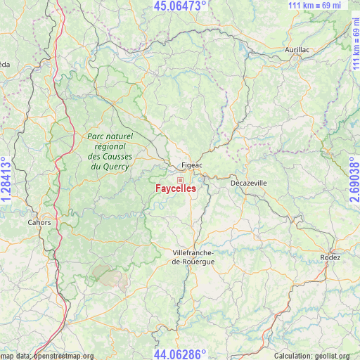
Faycelles GPS coordinates[2]
44° 33' 57.42" North, 1° 59' 14.136" East
| Map corner | latitude | longitude |
|---|---|---|
| Upper-left | 45.06473°, | 1.28413° |
| Center: | 44.56595°, | 1.98726° |
| Lower-right: | 44.06286°, | 2.69038° |
| Map W x H: | 111.4×111.4 km | = 69.2×69.2mi |
| max Lat: | 51.07786° ⇑83% North |
| Faycelles: | 44.56595° |
| min Lat: | ⇓17% South 41.3874° |
| min Long | Faycelles | max Long |
| -5.08615° | 1.98726° | 9.52242° |
| W 42.7%⇐ | ⇒57.3% E |
Elevation
Elevation of Faycelles is 324 m = 1063 ft, and this is 130.3 m = 427 ft above average elevation for this country.
| Max E: |
2333 m = 7654 ft | 16.8% |
| Faycelles | 324 m 1063 ft | |
| Avg. | 193.7 m = 635 ft | |
Min E: |
-1 m = -3 ft | 83.2% |
See also: France elevation on elevation.city.
Geographical zone
Faycelles is located in North temperate zone (between Tropic of Cancer and the Arctic Circle). Distance of this Northern Tropic circle is 2349.4 km =1459.8 mi to South.| Distance of | km | miles | from Faycelles |
|---|---|---|---|
| North Pole | 5051.8 | 3139 | to North |
| Arctic Circle | 2445.9 | 1519.8 | to North |
| Tropic Cancer | 2349.4 | 1459.8 | to South |
| Equator | 4955.3 | 3079.1 | to South |


Nearby cities:
15 places around Faycelles: (largest is in red/bold)
• Assier
14.9 km =9.3 mi,  324°
324°
• Bagnac-sur-Célé
18.1 km =11.2 mi,  51°
51°
• Boisse-Penchot
17.7 km =11 mi,  80°
80°
• Béduer
3.6 km =2.2 mi,  297°
297°
• Cajarc
14.5 km =9 mi,  232°
232°
• Capdenac-Gare
7.5 km =4.7 mi, 81°
• Cardaillac
12.6 km =7.8 mi,  3°
3°
• Figeac
5.9 km =3.7 mi,  36°
36°
• Lacapelle-Marival
18.7 km =11.6 mi,  344°
344°
• Lanuéjouls
20.5 km =12.7 mi,  136°
136°
• Livernon
14.6 km =9.1 mi,  308°
308°
• Livinhac-le-Haut
19.5 km =12.1 mi, 81°
• Saint-Santin
20.4 km =12.7 mi,  62°
62°
• Villeneuve
15.2 km =9.4 mi,  166°
166°
• Viviez
18.2 km =11.3 mi,  93°
93°
Sources, notices
• [Note1] Compared only with cities in France existing in our database
• [Src1] Map data: © OpenStreetMap contributors (CC-BY-SA)
• [Src2] Other city data from geonames.org with taken over terms of usage.
• [Src3] Geographical zone / Annual Mean Temperature by Robert A. Rohde @ Wikipedia
