Caours geodata
Caours (Hauts-de-France) is a populated place; located in France in Europe/Paris (GMT+2) time zone. With population of 619 people, there are 13004 cities with bigger population in this country. Compared to other cities in France, 94.4% of cities are located further ↓South; 58.4% of cities are located further →East and 96.3% of cities have higher elevation than Caours. Note1
Administrative division(s):
- Level 1: Hauts-de-France
- Level 2: Somme
- Level 3: Abbeville
- Level 4: Caours


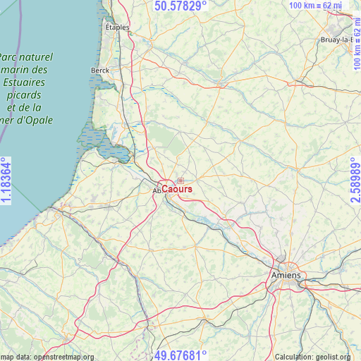
Caours GPS coordinates[2]
50° 7' 46.812" North, 1° 53' 12.336" East
| Map corner | latitude | longitude |
|---|---|---|
| Upper-left | 50.57829°, | 1.18364° |
| Center: | 50.12967°, | 1.88676° |
| Lower-right: | 49.67681°, | 2.58989° |
| Map W x H: | 100.2×100.2 km | = 62.3×62.3mi |
| max Lat: | 51.07786° ⇑5.6% North |
| Caours: | 50.12967° |
| min Lat: | ⇓94.4% South 41.3874° |
| min Long | Caours | max Long |
| -5.08615° | 1.88676° | 9.52242° |
| W 41.6%⇐ | ⇒58.4% E |
Elevation
Elevation of Caours is 13 m = 43 ft, and this is 180.7 m = 593 ft below average elevation for this country.
| Max E: |
2333 m = 7654 ft | 96.3% |
| Avg. | 193.7 m = 635 ft | |
| Caours | 13 m = 43 ft | |
Min E: |
-1 m = -3 ft | 3.7% |
See also: France elevation on elevation.city.
Geographical zone
Caours is located in North temperate zone (between Tropic of Cancer and the Arctic Circle). Distance of this North polar circle is 1827.3 km =1135.4 mi to North.| Distance of | km | miles | from Caours |
|---|---|---|---|
| North Pole | 4433.2 | 2754.7 | to North |
| Arctic Circle | 1827.3 | 1135.4 | to North |
| Tropic Cancer | 2968 | 1844.2 | to South |
| Equator | 5573.9 | 3463.5 | to South |


Nearby cities:
15 places around Caours: (largest is in red/bold)
• Abbeville
4.6 km =2.9 mi,  233°
233°
• Ailly-le-Haut-Clocher
9.5 km =5.9 mi,  126°
126°
• Buigny-Saint-Maclou
5.9 km =3.7 mi,  298°
298°
• Cambron
8.6 km =5.3 mi,  255°
255°
• Drucat
2 km =1.2 mi,  327°
327°
• Huchenneville
10.7 km =6.6 mi,  215°
215°
• Long
11.9 km =7.4 mi,  146°
146°
• Mareuil-Caubert
7.9 km =4.9 mi,  210°
210°
• Moyenneville
11.7 km =7.3 mi,  236°
236°
• Nouvion
10.7 km =6.6 mi,  316°
316°
• Pont-Remy
9.1 km =5.7 mi,  166°
166°
• Sailly-Flibeaucourt
10.2 km =6.3 mi,  306°
306°
• Saint-Riquier
4.3 km =2.7 mi,  86°
86°
• Vauchelles-les-Quesnoy
3.3 km =2.1 mi,  184°
184°
• Épagne-Épagnette
6.5 km =4 mi,  188°
188°
Sources, notices
• [Note1] Compared only with cities in France existing in our database
• [Src1] Map data: © OpenStreetMap contributors (CC-BY-SA)
• [Src2] Other city data from geonames.org with taken over terms of usage.
• [Src3] Geographical zone / Annual Mean Temperature by Robert A. Rohde @ Wikipedia
