Épagne-Épagnette geodata
Épagne-Épagnette (Hauts-de-France) is a populated place; located in France in Europe/Paris (GMT+2) time zone. With population of 576 people, there are 13727 cities with bigger population in this country. Compared to other cities in France, 94% of cities are located further ↓South; 58.6% of cities are located further →East and 94.4% of cities have higher elevation than Épagne-Épagnette. Note1
Administrative division(s):
- Level 1: Hauts-de-France
- Level 2: Somme
- Level 3: Abbeville
- Level 4: Épagne-Épagnette


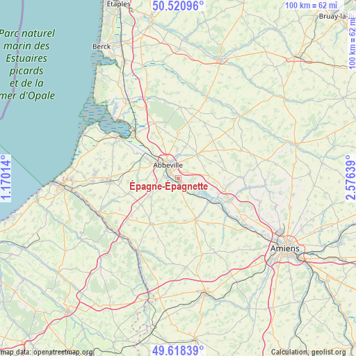
Épagne-Épagnette GPS coordinates[2]
50° 4' 18.48" North, 1° 52' 23.772" East
| Map corner | latitude | longitude |
|---|---|---|
| Upper-left | 50.52096°, | 1.17014° |
| Center: | 50.0718°, | 1.87327° |
| Lower-right: | 49.61839°, | 2.57639° |
| Map W x H: | 100.4×100.4 km | = 62.4×62.4mi |
| max Lat: | 51.07786° ⇑6% North |
| Épagne-Épagnette: | 50.0718° |
| min Lat: | ⇓94% South 41.3874° |
| min Long | Épagne-Épagne | max Long |
| -5.08615° | 1.87327° | 9.52242° |
| W 41.4%⇐ | ⇒58.6% E |
Elevation
Elevation of Épagne-Épagnette is 19 m = 62 ft, and this is 174.7 m = 573 ft below average elevation for this country.
| Max E: |
2333 m = 7654 ft | 94.4% |
| Avg. | 193.7 m = 635 ft | |
| Épagne-Épagnette | 19 m = 62 ft | |
Min E: |
-1 m = -3 ft | 5.6% |
See also: France elevation on elevation.city.
Geographical zone
Épagne-Épagnette is located in North temperate zone (between Tropic of Cancer and the Arctic Circle). Distance of this North polar circle is 1833.7 km =1139.4 mi to North.| Distance of | km | miles | from Épagne-Épagnette |
|---|---|---|---|
| North Pole | 4439.6 | 2758.6 | to North |
| Arctic Circle | 1833.7 | 1139.4 | to North |
| Tropic Cancer | 2961.5 | 1840.2 | to South |
| Equator | 5567.5 | 3459.5 | to South |


Nearby cities:
15 places around Épagne-Épagnette: (largest is in red/bold)
• Abbeville
4.6 km =2.9 mi,  324°
324°
• Ailly-le-Haut-Clocher
8.7 km =5.4 mi,  84°
84°
• Buigny-Saint-Maclou
10.2 km =6.3 mi,  335°
335°
• Cambron
8.5 km =5.3 mi,  300°
300°
• Caours
6.5 km =4 mi,  8°
8°
• Drucat
8.1 km =5 mi,  359°
359°
• Hallencourt
8.9 km =5.5 mi,  178°
178°
• Huchenneville
5.7 km =3.5 mi,  246°
246°
• Huppy
9.4 km =5.8 mi,  236°
236°
• Long
8.3 km =5.2 mi,  114°
114°
• Mareuil-Caubert
3.1 km =1.9 mi,  262°
262°
• Moyenneville
8.8 km =5.5 mi,  269°
269°
• Pont-Remy
3.9 km =2.4 mi,  128°
128°
• Saint-Riquier
8.6 km =5.3 mi,  38°
38°
• Vauchelles-les-Quesnoy
3.2 km =2 mi, 12°
Sources, notices
• [Note1] Compared only with cities in France existing in our database
• [Src1] Map data: © OpenStreetMap contributors (CC-BY-SA)
• [Src2] Other city data from geonames.org with taken over terms of usage.
• [Src3] Geographical zone / Annual Mean Temperature by Robert A. Rohde @ Wikipedia
